Hesel | |
|---|---|
 Coat of arms | |
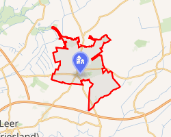
Location of Hesel
within Leer district | |
 Location of Hesel | |
Hesel Hesel | |
| Coordinates: 53°18′N 7°36′E / 53.300°N 7.600°E / 53.300; 7.600 | |
| Country | Germany |
| State | Lower Saxony |
| District | Leer |
| Municipal assoc. | Hesel |
| Government | |
| • Mayor | Heiko Müller (CDU) |
| Area | |
• Total | 44.02 km2 (17.00 sq mi) |
| Highest elevation | 17 m (56 ft) |
| Lowest elevation | 12 m (39 ft) |
| Population (2024-12-31)1 | |
• Total | 4,714 |
| • Density | 107.1/km2 (277.4/sq mi) |
| Time zone | UTC+01:00 (CET) |
| • Summer (DST) | UTC+02:00 (CEST) |
| Postal codes | 26835 |
| Dialling codes | 0 49 50 |
| Vehicle registration | LER |
| Website | www.hesel.de |
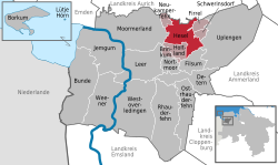
Hesel is a municipality in Leer district. It is situated approximately 12 km (7.5 mi) northeast of Leer, and 25 km (16 mi) east of Emden.
Hesel is also the seat of the Samtgemeinde ("collective municipality") Hesel.