Heille | |
|---|---|
Hamlet | |
 | |
 Flag  Coat of arms | |
Heille Location in the province of Zeeland in the Netherlands Show map of ZeelandHeille Heille (Netherlands) Show map of Netherlands | |
| Coordinates: 51°15′57″N 3°24′48″E / 51.2657°N 3.4133°E / 51.2657; 3.4133 | |
| Country | Netherlands |
| Province | Zeeland |
| Municipality | Sluis |
| Time zone | UTC+1 (CET) |
| • Summer (DST) | UTC+2 (CEST) |
| Postal code | 45241 |
| Dialing code | 01172 |
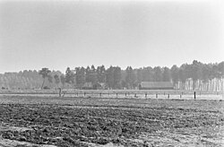
Heille is a hamlet in the Dutch province of Zeeland. It is located on the Belgium border, about 2 km west of Aardenburg in the municipality of Sluis.
Heille is not a statistical entity,1 and the postal authorities have placed it under Sluis.2
Heille was a separate municipality until 1880.3
References
References
- "Kerncijfers wijken en buurten 2021". Central Bureau of Statistics. Retrieved 21 April 2022.
not found
- "Postcode 4524 in Sluis". Postcode bij adres (in Dutch). Retrieved 21 April 2022.
- Ad van der Meer and Onno Boonstra, "Repertorium van Nederlandse gemeenten", KNAW, 2006. "KNAW > Publicaties > Detailpagina". Archived from the original on 2007-02-20. Retrieved 2009-12-03.