| Site of Special Scientific Interest | |
 | |
 Location of Harting Downs. | |
| Area of search | West Sussex |
|---|---|
| Grid reference | SU 800 1791 |
| Interest | Biological |
| Area | 336.3 hectares (831 acres)1 |
| Notification date | 19871 |
| Location map | Magic Map |
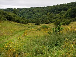
Harting Downs is a 336.3-hectare (831-acre) biological Site of Special Scientific Interest west of Midhurst in West Sussex.12 It is a Nature Conservation Review site, Grade I3 and an area of 206.6 hectares (511 acres) is a Local Nature Reserve which is owned and managed by the National Trust.456
This site consists of several parallel valleys on the steep slope of the South Downs. Habitats are chalk grassland, which is being invaded by scrub, together with areas of long-established woodland. The site is important for insects, with a nationally rare snail, Helicondonta obvoluta, two uncommon moths, the wood tiger and the maple prominent, and many rove beetles.7
References
References
- "Designated Sites View: Harting Downs". Sites of Special Scientific Interest. Natural England. Retrieved 30 April 2019.
- "Map of Harting Downs". Sites of Special Scientific Interest. Natural England. Retrieved 30 April 2019.
- Ratcliffe, Derek, ed. (1977). A Nature Conservation Review. Vol. 2. Cambridge, UK: Cambridge University Press. p. 118. ISBN 0521-21403-3.
- "Harting Down". Local Nature Reserves. Natural England. Retrieved 30 April 2019.
- "Map of Harting Down". Local Nature Reserves. Natural England. Retrieved 30 April 2019.
- "Harting Down". National Trust. Retrieved 30 April 2019.
- "Harting Downs citation" (PDF). Sites of Special Scientific Interest. Natural England. Retrieved 30 April 2019.