The South Yorkshire Supertram is a light rail network which operates in Sheffield and Rotherham in South Yorkshire. It is owned and operated by the South Yorkshire People's Network and the first phase of the network opened on 21 March 1994.1 A tram-train extension to Parkgate in Rotherham opened in October 2018.2 The most recent stop on the Supertram network, opened on 9 April 2026, is the Magna tram-train stop, built on the tram-train extension to Parkgate.3
There are a total of four routes and 51 tram stops, all listed in the table below.
Key
B Blue
P Purple
Y Yellow
TT Tram-train (Black)
Network diagram
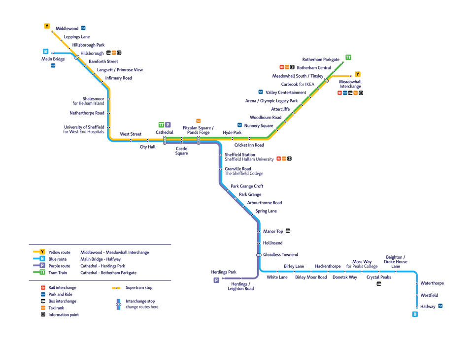
List of tram stops
| Station | Photo | Opened | Routes | Location | Codea | Notes |
|---|---|---|---|---|---|---|
| Arbourthorne Road |  |
22 August 1994 | B P | Park Grange Road, Arbourthorne 53°21′48″N 1°26′52″W / 53.3634°N 1.4479°W / 53.3634; -1.4479 |
ARR | |
| Arena Olympic Legacy Park |
 |
21 March 1994 | Y TT | Coleridge Road, Greenland 53°23′54″N 1°25′13″W / 53.3982°N 1.4204°W / 53.3982; -1.4204 |
ARSb | Serves the Olympic Legacy Park, Sheffield Arena and English Institute of Sport, Sheffield. Built with double-length platforms to accommodate crowds exiting events at the arena. Opened as "Arena / Don Valley Stadium" and renamed when the stadium was demolished in 2013. |
| Attercliffe |  |
21 March 1994 | Y TT | Shortridge Street, Attercliffe 53°23′32″N 1°25′48″W / 53.3923°N 1.4300°W / 53.3923; -1.4300 |
ATT | |
| Bamforth Street |  |
23 October 1995 | B Y | Langsett Road, Hillsborough 53°23′56″N 1°29′33″W / 53.3989°N 1.4925°W / 53.3989; -1.4925 |
BAS | |
| Beighton Drakehouse Lane |
 |
27 March 1995 | B | Eckington Way, Beighton 53°20′30″N 1°20′51″W / 53.3417°N 1.3474°W / 53.3417; -1.3474 |
BDH | Serves the east side of Crystal Peaks shopping centre. |
| Birley Lane |  |
27 March 1995 | B | Birley Lane, Birley 53°20′25″N 1°23′58″W / 53.3403°N 1.3994°W / 53.3403; -1.3994 |
BIL | Serves The Birley Academy and Birley Wood Golf Course. |
| Birley Moor Road |  |
27 March 1995 | B | Sheffield Road, Birley 53°20′30″N 1°23′19″W / 53.3416°N 1.3886°W / 53.3416; -1.3886 |
BMR | |
| Carbrook for IKEA |
 |
21 March 1994 | Y TT | Lock House Road, Carbrook 53°24′20″N 1°24′39″W / 53.4055°N 1.4108°W / 53.4055; -1.4108 |
CAR | Serves the Sheffield IKEA store, which opened on 28 September 20175 and contains a small park and ride car park. Also serves the Meadowhall Retail Park. |
| Castle Square |  |
18 February 1995 | B P Y TT | Castle Square, City Centre 53°22′59″N 1°27′58″W / 53.3831°N 1.4660°W / 53.3831; -1.4660 |
CAS | Serves the Crucible and Lyceum Theatres, O2 Academy Sheffield, Tudor Square and the Winter Gardens. Connections available to bus services at Arundel Gate Interchange. Built on the site of the locally famous Hole in the Road roundabout, which remains outlined in the circular pattern of the paving slabs around the tram stop. |
| Cathedral |  |
18 February 1995 | B P Y TT | Church Street, City Centre 53°22′57″N 1°28′08″W / 53.3826°N 1.4690°W / 53.3826; -1.4690 |
CAT | Constructed on the front churchyard of Sheffield Cathedral. Serves the Fargate, High Street and Pinstone Street shopping area, the Peace Gardens and Sheffield Town Hall. Terminus of the Purple and Tram-train routes. |
| City Hall |  |
27 February 1995 | B Y | West Street, City Centre 53°22′54″N 1°28′21″W / 53.3817°N 1.4726°W / 53.3817; -1.4726 |
CIH | Serves Barker's Pool, Leopold Square, Orchard Square and Sheffield City Hall. Staggered platforms. |
| Cricket Inn Road |  |
21 March 1994 | Y TT | Cricket Inn Road, Wybourn 53°23′02″N 1°26′47″W / 53.3840°N 1.4465°W / 53.3840; -1.4465 |
CIR | |
| Crystal Peaks |  |
27 March 1995 | B | Ochre Dike Lane, Waterthorpe 53°20′30″N 1°21′22″W / 53.3417°N 1.3560°W / 53.3417; -1.3560 |
CRP | Serves the Crystal Peaks shopping centre and retail park and Drakehouse Retail Park, with connections to local bus services available at Crystal Peaks bus station. |
| Donetsk Way |  |
27 March 1995 | B | Donetsk Way, Owlthorpe 53°20′30″N 1°22′13″W / 53.3417°N 1.3702°W / 53.3417; -1.3702 |
DOW | Donetsk Way is named for Sheffield's twin city of Donetsk, Ukraine. |
| Fitzalan Square Ponds Forge |
 |
21 March 1994 | B P Y TT | Fitzalan Square, City Centre 53°22′59″N 1°27′50″W / 53.3831°N 1.4638°W / 53.3831; -1.4638 |
FISc | Serves the Ponds Forge sports centre, the Haymarket and Waingate shopping areas, the former Castle Market and The Wicker. Connections to local and national bus services available nearby at Sheffield Interchange. Opened as "Commercial Street". |
| Gleadless Townend |  |
5 December 1994 | B P | Ridgeway Road, Gleadless Townend 53°20′45″N 1°25′33″W / 53.3459°N 1.4259°W / 53.3459; -1.4259 |
GLT | Serves the Gleadless Townend shopping precinct. Interchange point between Blue and Purple routes. |
| Granville Road The Sheffield College |
 |
22 August 1994 | B P | Granville Road, City Centre 53°22′27″N 1°27′40″W / 53.3743°N 1.4612°W / 53.3743; -1.4612 |
GRR | Serves The Sheffield College (City Campus) as well as All Saints Catholic High School. Closest tram stop to The Leadmill and Bramall Lane stadium, home of Sheffield United. Staggered platforms. |
| Hackenthorpe |  |
27 March 1995 | B | Sheffield Road, Hackenthorpe 53°20′37″N 1°22′52″W / 53.3436°N 1.3810°W / 53.3436; -1.3810 |
HAC | |
| Halfway Park and Ride |
 |
27 March 1995 | B | Eckington Way, Halfway 53°19′43″N 1°20′39″W / 53.3285°N 1.3442°W / 53.3285; -1.3442 |
HAL | Single-platform terminus, with a park and ride car park adjacent. The platform is double-faced, with the opposite side to the tram line functioning as a bus terminus. |
| Herdings Leighton Road |
 |
3 April 1995 | P | Norton Avenue, Herdings 53°20′33″N 1°25′56″W / 53.3424°N 1.4323°W / 53.3424; -1.4323 |
HLR | Serves Woodlands Primary School (East Main entrance). |
| Herdings Park |  |
3 April 1995 | P | Raeburn Road, Herdings 53°20′33″N 1°26′21″W / 53.3424°N 1.4392°W / 53.3424; -1.4392 |
HEP | Single-platform terminus, with bus terminus in turning circle nearby. Named for Herdings Park and serves the Herdings Twin Towers and Woodlands Primary School (West entrance). |
| Hillsborough Interchange |  |
23 October 1995 | B Y | Langsett Road, Hillsborough 53°24′07″N 1°29′59″W / 53.4019°N 1.4998°W / 53.4019; -1.4998 |
HIL | Located in the commercial centre of Hillsborough next to the River Loxley, with local bus connections available from the integrated bus station. Serves Hillsborough Barracks and the Tramlines Festival. |
| Hillsborough Park |  |
23 October 1995 | Y | Middlewood Road, Hillsborough 53°24′15″N 1°30′13″W / 53.4043°N 1.5035°W / 53.4043; -1.5035 |
HIP | Serves Hillsborough Park and Owlerton Stadium. |
| Hollinsend |  |
5 December 1994 | B P | Ridgeway Road, Hollinsend 53°21′07″N 1°25′28″W / 53.3519°N 1.4244°W / 53.3519; -1.4244 |
HOL | |
| Hyde Park |  |
21 March 1994 | Y TT | Cricket Inn Road, Hyde Park 53°23′05″N 1°27′09″W / 53.3846°N 1.4524°W / 53.3846; -1.4524 |
HYP | |
| Infirmary Road |  |
23 October 1995 | B Y | Infirmary Road, Upperthorpe 53°23′27″N 1°28′57″W / 53.3909°N 1.4825°W / 53.3909; -1.4825 |
INR | |
| Langsett Primrose View |
 |
23 October 1995 | B Y | Langsett Road, Walkley 53°23′45″N 1°29′21″W / 53.3958°N 1.4893°W / 53.3958; -1.4893 |
LPV | |
| Leppings Lane |  |
23 October 1995 | Y | Middlewood Road, Owlerton 53°24′37″N 1°30′15″W / 53.4102°N 1.5041°W / 53.4102; -1.5041 |
LEL | Serves Hillsborough Stadium, home of Sheffield Wednesday. Staggered platforms, which are double-width compared to the Supertram standard in order to accommodate crowds exiting football matches. |
| Magna |  |
9 April 2026 | TT | Magna Way, Templeborough (Rotherham) 53°25′13″N 1°23′21″W / 53.4202°N 1.3892°W / 53.4202; -1.3892 |
MGAd | Serves the Magna Science Adventure Centre and also functions as a park and ride site. Staggered platforms. Most recent addition to the Supertram network. |
| Malin Bridge |  |
23 October 1995 | B | Loxley New Road, Malin Bridge 53°24′03″N 1°30′30″W / 53.4007°N 1.5082°W / 53.4007; -1.5082 |
MAB | Single-platform terminus. |
| Manor Top |  |
5 December 1994 | B P | Ridgeway Road, Manor Top 53°21′35″N 1°25′43″W / 53.3597°N 1.4286°W / 53.3597; -1.4286 |
MTEe | Serves the Manor Top shopping precinct. A small bus station with connections to local bus services is located behind the outbound platform. Opened as "Manor Top Elm Tree" and renamed when the nearby Elm Tree pub was demolished in 2016. |
| Meadowhall Interchange |  |
21 March 1994 | Y | Meadowhall Road, Meadowhall 53°25′00″N 1°24′49″W / 53.4168°N 1.4135°W / 53.4168; -1.4135 |
MEI | Terminus, consisting of two platforms in an island layout, although one is rarely used. Serves Meadowhall Shopping Centre. Integrated with the adjacent bus and railway stations, with connections to local and national bus services and National Rail services. |
| Middlewood Park and Ride |
 |
23 October 1995 | Y | Middlewood Road, Middlewood 53°24′57″N 1°30′36″W / 53.4158°N 1.5100°W / 53.4158; -1.5100 |
MID | Terminus, consisting of two platforms in sequence, although one is rarely used. Large park and ride car park behind the platform. |
| Moss Way for Peaks College |
 |
27 March 1995 | B | Moss Way, Owlthorpe 53°20′32″N 1°21′45″W / 53.3421°N 1.3626°W / 53.3421; -1.3626 |
MOW | Serves The Sheffield College (Peaks Campus). |
| Netherthorpe Road |  |
23 October 1995 | B Y | Netherthorpe Road, Netherthorpe 53°23′05″N 1°28′57″W / 53.3847°N 1.4824°W / 53.3847; -1.4824 |
NER | Serves The Ponderosa. Uniquely consists of two platforms in an island layout accessed via a central subway due to capacity constraints, as the tram stop is situated in the central reservation of a dual carriageway. |
| Nunnery Square Park and Ride |
 |
5 November 1998 | Y TT | Woodbourn Road, Wybourn 53°23′08″N 1°26′30″W / 53.3855°N 1.4417°W / 53.3855; -1.4417 |
NCSf | Located next to Nunnery Square tram depot. Constructed in 1994 as a staff-only halt known as "Nunnery Crew Stop", the halt was subsequently upgraded and opened to the public with the construction of an adjacent park and ride site off the Sheffield Parkway. |
| Park Grange Croft |  |
1 December 2001 | B P | Park Grange Road, Norfolk Park 53°22′12″N 1°27′31″W / 53.3701°N 1.4585°W / 53.3701; -1.4585 |
PAK | Serves The Sheffield College - Advanced Technology Centre and Bramall Lane Stadium, home to Sheffield United. |
| Park Grange Road |  |
22 August 1994 | B P | Park Grange Road, Norfolk Park 53°22′02″N 1°27′18″W / 53.3671°N 1.4549°W / 53.3671; -1.4549 |
PAG | Staggered platforms. Opened as "Park Grange" and renamed when Park Grange Croft opened in 2001. |
| Parkgate |  |
25 October 2018 | TT | Stonerow Way, Parkgate (Rotherham) 53°26′34″N 1°20′36″W / 53.4429°N 1.3434°W / 53.4429; -1.3434 |
PAQd | Single-platform terminus. Serves Parkgate Shopping Park and functions as a park and ride site. |
| Rotherham Central |  |
25 October 2018 | TT | Central Road, Rotherham 53°25′52″N 1°21′41″W / 53.4310°N 1.3615°W / 53.4310; -1.3615 |
RMCd | Serves Rotherham town centre. Integrated with the railway station for connections to local National Rail services, with connections to local bus services available from nearby Rotherham Interchange. |
| Shalesmoor for Kelham Island |
 |
27 February 1995 | B Y | Penistone Road, Kelham Island 53°23′19″N 1°28′40″W / 53.3887°N 1.4779°W / 53.3887; -1.4779 |
SHA | Serves the Kelham Island and Neepsend leisure districts, including Kelham Island Museum and Yellow Arch Studios. |
| Sheffield Station Sheffield Hallam University |
 |
22 August 1994 | B P | Granville Street, City Centre 53°22′40″N 1°27′40″W / 53.3778°N 1.4612°W / 53.3778; -1.4612 |
SHS | Integrated with the railway station for connections to local and national National Rail services, and also serves the Park Hill development and Sheffield Hallam University (City Campus). Main stop resited 150 m (490 ft) south in 2002 as part of the redevelopment of the railway station. The original three northern platforms remain in situ and are rarely used in times of service disruption. |
| Spring Lane |  |
22 August 1994 | B P | Park Grange Road, Arbourthorne 53°21′58″N 1°26′19″W / 53.3662°N 1.4387°W / 53.3662; -1.4387 |
SPL | |
| Tinsley Meadowhall South |
 |
21 March 1994 | Y TT | Meadowhall Way, Tinsley 53°24′51″N 1°24′18″W / 53.4142°N 1.4050°W / 53.4142; -1.4050 |
TIN | Serves the south side of Meadowhall Shopping Centre. |
| University of Sheffield for West End Hospitals |
 |
27 February 1995 | B Y | Upper Hanover Street, City Centre 53°22′51″N 1°29′02″W / 53.3807°N 1.4840°W / 53.3807; -1.4840 |
UOS | Serves the Royal Hallamshire Hospital, Sheffield Children's Hospital, the University of Sheffield and Weston Park (including Weston Park Hospital and Weston Park Museum). |
| Valley Centertainment |  |
5 November 1998 | Y TT | Broughton Lane, Carbrook 53°24′08″N 1°24′45″W / 53.4022°N 1.4126°W / 53.4022; -1.4126 |
VAE | Constructed as part of the Valley Centertainment leisure park development, opening on the same day as the anchor Cineworld cinema. As well as serving the leisure park, this stop functions as a park and ride site, with dedicated car parking behind the cinema. |
| Waterthorpe |  |
27 March 1995 | B | Eckington Way, Waterthorpe 53°20′11″N 1°20′42″W / 53.3364°N 1.3450°W / 53.3364; -1.3450 |
WAT | Serves Westfield School, and is the closest tram stop to Rother Valley Country Park. The city-bound platform is double-faced, with the side opposite the tram line functioning as a bus stop. |
| West Street |  |
27 February 1995 | B Y | West Street, City Centre 53°22′50″N 1°28′38″W / 53.3805°N 1.4773°W / 53.3805; -1.4773 |
WES | Serves the bars and pubs of Division Street and West Street as well as Devonshire Green. |
| Westfield |  |
27 March 1995 | B | Eckington Way, Westfield 53°19′54″N 1°20′38″W / 53.3317°N 1.3438°W / 53.3317; -1.3438 |
WED | |
| White Lane |  |
27 March 1995 | B | White Lane, Charnock 53°20′35″N 1°25′11″W / 53.3430°N 1.4197°W / 53.3430; -1.4197 |
WHL | |
| Woodbourn Road |  |
21 March 1994 | Y TT | Woodbourn Road, Attercliffe 53°23′20″N 1°26′04″W / 53.3888°N 1.4345°W / 53.3888; -1.4345 |
WOR |
Notes
Notes
- Each tram stop is given a three-letter identifier code.4
- Code derived from the stop's original name, "Arena / Don Valley Stadium".
- Formerly "COM" when the stop was named "Commercial Street".
- National Rail station code.
- Code derived from the stop's original name, "Manor Top Elm Tree".
- Code derived from the stop's original name, "Nunnery Crew Stop".
References
References
- Courtenay, Peter. "Sheffield Supertram: History". TheTrams.co.uk. Retrieved 19 August 2007.
- "Supertram | Tram Train". www.stagecoachbus.com. Archived from the original on 21 October 2018. Retrieved 21 October 2018.
- "Magna tram station opening soon with 100 new park and ride spaces". The Star. 23 March 2026. Retrieved 23 March 2026.
- "Section codes for overhead line electrification (OLE) installations: independent lines". Railway Codes. Railway Observer. Retrieved 7 April 2026.
- "IKEA opens their 20th UK store in Sheffield". Insight DIY. Retrieved 7 April 2026.