Hörsel | |
|---|---|
 | |
Location of Hörsel
within Gotha district | |
 Location of Hörsel | |
Hörsel Hörsel | |
| Coordinates: 50°55′N 10°35′E / 50.917°N 10.583°E / 50.917; 10.583 | |
| Country | Germany |
| State | Thuringia |
| District | Gotha |
| Government | |
| • Mayor (2023–29) | Florian Seitz1 |
| Area | |
• Total | 70.44 km2 (27.20 sq mi) |
| Elevation | 300 m (980 ft) |
| Population (2024-12-31)2 | |
• Total | 4,636 |
| • Density | 65.81/km2 (170.5/sq mi) |
| Time zone | UTC+01:00 (CET) |
| • Summer (DST) | UTC+02:00 (CEST) |
| Postal codes | 99880 |
| Dialling codes | 03622 |
| Vehicle registration | GTH |
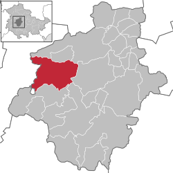
Hörsel (German pronunciation: [ˈhœʁzl̩] ⓘ) is a municipality in the district of Gotha, in Thuringia, Germany. It was named after the river Hörsel, that flows through the municipality. It was formed on 1 December 2011 by the merger of the former municipalities Aspach, Ebenheim, Fröttstädt, Hörselgau, Laucha, Mechterstädt, Metebach, Teutleben, Trügleben and Weingarten.3 Since March 1994, these municipalities had cooperated in the Verwaltungsgemeinschaft ("collective municipality") Hörsel. This Verwaltungsgemeinschaft was disbanded on 1 December 2011. The seat of the municipality and of the former Verwaltungsgemeinschaft is in Hörselgau.
References
References
- Gewählte Bürgermeister - aktuelle Landesübersicht, Freistaat Thüringen. Retrieved 25 June 2024.
- "Bevölkerung der Gemeinden vom Thüringer Landesamt für Statistik" (in German). Thüringer Landesamt für Statistik.
- "Gebietsänderungen vom 01. Januar bis 31. Dezember 2011". Statistisches Bundesamt (in German). Retrieved 2025-02-22.