| Goose Gap | |
|---|---|
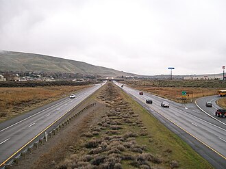 Interstate 182 approaching Goose Gap. | |
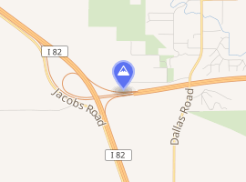 Interactive map of Goose Gap | |
| Elevation | 860 ft (260 m)1 |
| Traversed by |  I-182 & I-182 &  US 122 US 122 |
| Third Approach | |
| Location | Benton County, Washington1 |
| Range | Yakima Fold Belt |
| Coordinates | 46°14′42″N 119°21′26″W / 46.24500°N 119.35722°W / 46.24500; -119.357221 |
Goose Gap is a small pass connecting Badger Mountain to Candy Mountain to the west of Richland, Washington. It lies significantly higher than most of the Tri-Cities and is crossed by Interstate 182 just after its western terminus. An average of 18,000 people cross Goose Gap daily.3
There are residential areas on both sides of I-182 to the east of the gap, but to the west is mostly agriculture. The non-profit organization Friends of Badger Mountain is planning a new hiking trail to connect Badger Mountain to Candy Mountain, which will cross Goose Gap in a north-to-south direction, perpendicular to the Interstate.4
References
References
- "Goose Gap". Geographic Names Information System. United States Geological Survey, United States Department of the Interior. Retrieved August 31, 2015.
- Google Maps Accessed 2015-08-31
- WSDOT - Annual Traffic Report Archived 2015-07-13 at the Wayback Machine Accessed 2015-08-31
- Current Campaign - Friends of Badger Mountain Archived 2015-08-15 at the Wayback Machine Accessed 2015-08-31.