Gilja | |
|---|---|
Village | |
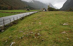 View of the farmland just outside the village | |
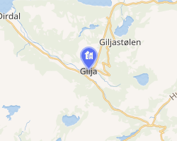 Interactive map of Gilja | |
| Coordinates: 58°48′25″N 6°15′32″E / 58.80698°N 6.25899°E / 58.80698; 6.25899 | |
| Country | Norway |
| Region | Western Norway |
| County | Rogaland |
| District | Jæren |
| Municipality | Gjesdal Municipality |
| Area | |
• Total | 0.31 km2 (0.12 sq mi) |
| Elevation | 77 m (253 ft) |
| Population (2025)1 | |
• Total | 390 |
| • Density | 1,258/km2 (3,260/sq mi) |
| Time zone | UTC+01:00 (CET) |
| • Summer (DST) | UTC+02:00 (CEST) |
| Post Code | 4335 Dirdal |
Gilja3 is a village in Gjesdal Municipality in Rogaland county, Norway. The village is located about 5 kilometres (3.1 mi) southeast of the village of Dirdal in the Dirdalen valley. The Frafjord Tunnel connects Gilja with the village of Frafjord, located in the next valley on the other side of the mountains.4
The 0.31-square-kilometre (77-acre) village has a population (2025) of 390 and a population density of 1,258 inhabitants per square kilometre (3,260/sq mi).1 The village is the site of a window factory which employs many of the local inhabitants.4
References
References
- Statistisk sentralbyrå (27 October 2025). "Urban settlements. Population and area, by municipality".
- "Gilja, Gjesdal". yr.no. Retrieved 6 April 2026.
- "Informasjon om stadnamn". Norgeskart (in Norwegian). Kartverket. Retrieved 6 April 2026.
- Thorsnæs, Geir; Lauritzen, Per Roger, eds. (2 March 2026). "Gilja". Store norske leksikon (in Norwegian). Foreningen Store norske leksikon. Retrieved 6 April 2026.