Gamaches | |
|---|---|
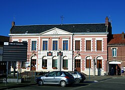 The town hall in Gamaches | |
 Coat of arms | |
 Location of Gamaches | |
Gamaches Gamaches | |
| Coordinates: 49°59′15″N 1°33′29″E / 49.9875°N 1.5581°E / 49.9875; 1.5581 | |
| Country | France |
| Region | Hauts-de-France |
| Department | Somme |
| Arrondissement | Abbeville |
| Canton | Gamaches |
| Intercommunality | CC Villes Sœurs |
| Government | |
| • Mayor (2020–2026) | Jean-Paul Mongne1 |
Area 1 | 9.92 km2 (3.83 sq mi) |
| Population (2023)2 | 2,397 |
| • Density | 242/km2 (626/sq mi) |
| Time zone | UTC+01:00 (CET) |
| • Summer (DST) | UTC+02:00 (CEST) |
| INSEE/Postal code | 80373 /80220 |
| Elevation | 19–126 m (62–413 ft) (avg. 32 m or 105 ft) |
| 1 French Land Register data, which excludes lakes, ponds, glaciers > 1 km2 (0.386 sq mi or 247 acres) and river estuaries. | |
Gamaches (French pronunciation: [ɡamaʃ]) is a commune in the Somme department in Hauts-de-France in northern France.
Geography
Gamaches is situated on the D1015, on the banks of the river Bresle, the border with Seine-Maritime, some 18 miles (29 km) southwest of Abbeville.
Huge lakes to the west of the town are a paradise for naturalists, anglers and water sports enthusiasts.
History
- 1471 Louis XI and the Burgundians wage war in and around the town. A year or so later, Charles the Bold ravaged Picardy in the continuing battle with Burgundy. The plague decimated not only the troops but also the local populace.
- Glass bottles have been manufactured in Gamaches since 1922.3
Population
| Year | Pop. | ±% p.a. |
|---|---|---|
| 1968 | 3,216 | — |
| 1975 | 3,467 | +1.08% |
| 1982 | 3,270 | −0.83% |
| 1990 | 3,099 | −0.67% |
| 1999 | 2,949 | −0.55% |
| 2007 | 2,847 | −0.44% |
| 2012 | 2,730 | −0.84% |
| 2017 | 2,548 | −1.37% |
| 2023 | 2,397 | −1.01% |
| Source: INSEE4 | ||
Places of interest
- The war memorial5
- The thirteenth-century church of Saint-Pierre and Saint-Paul, with its flamboyant gothic tower, is the result of successive architectural influences.
- The old railway line, opened in 1872 and closed in 1993 6

- The lakes
References
References
- "Répertoire national des élus: les maires". data.gouv.fr, Plateforme ouverte des données publiques françaises (in French). 2 December 2020.
- "Populations de référence 2023" (in French). National Institute of Statistics and Economic Studies. 18 December 2025.
- Base Mérimée: Usine de flaconnage S.A. des Verreries Saint-Martin, puis Annebicque, puis Verrerie de Picardie, puis Verrerie de Courval, Ministère français de la Culture. (in French)
- Population municipale entre 1968 et 2023, INSEE
- Base Mérimée: Monument aux morts de la Guerre de 1914-1918 et de la Guerre de 1939-1945, Ministère français de la Culture. (in French)
- "Source:Fcvnet". Archived from the original on 2012-02-10. Retrieved 2008-02-18.