Foronda | |
|---|---|
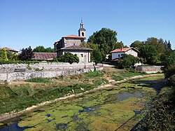 View of the Zalla river and the parish church in Foronda | |
Foronda Foronda Foronda | |
| Coordinates: 42°53′54″N 2°43′22″W / 42.89838°N 2.72276°W / 42.89838; -2.72276 | |
| Country | Spain |
| Autonomous community | Basque Country |
| Province | Álava |
| Comarca | Vitoria-Gasteiz |
| Municipality | Vitoria-Gasteiz |
| Area | |
• Total | 3.51 km2 (1.36 sq mi) |
| Elevation | 517 m (1,696 ft) |
| Population (2022)1 | |
• Total | 47 |
| • Density | 13/km2 (35/sq mi) |
| Postal code | 01196 |
Foronda is a hamlet and concejo in the municipality of Vitoria-Gasteiz, in Álava province, Basque Country, Spain. It is located next to the Zalla river and in close proximity to Vitoria Airport.2
Climate
This region experiences warm (but not hot) and dry summers, August has the warmest month with an average temperature of 19.1 °C (66.4 °F). According to the Köppen Climate Classification system, Foronda has a marine west coast climate, abbreviated "Cfb" on climate maps.3
References
References
- "Nomenclátor: Núcleos". Entidades Locales de Álava (in Spanish). Diputación Foral de Álava. 1 January 2022. Retrieved 4 September 2023.
- Triviño, Borja (30 November 2020). "Foronda: Un pueblo con mucha historia". GasteizHoy (in Spanish). Retrieved 4 September 2023.
- "Foronda, Spain Köppen Climate Classification". Weatherbase. Retrieved 4 September 2023.