| Foo Pass | |
|---|---|
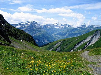 View from the pass towards the canton of Glarus | |
| Elevation | 2,223 m (7,293 ft) |
| Traversed by | Trail |
| Location | Glarus/St. Gallen, Switzerland |
| Range | Glarus Alps |
| Coordinates | 46°56′34″N 09°14′17.5″E / 46.94278°N 9.238194°E / 46.94278; 9.238194 |
Foo Pass Location in Switzerland | |
 Interactive map of Foo Pass | |
The Foo Pass (German: Foopass) is a mountain pass of the Glarus Alps, located on the border between the Swiss cantons of St. Gallen and Glarus, at an elevation of 2,223 m (7,293 ft). It crosses the col between the peaks of Foostock and Piz Sardona.12
The pass is traversed by a trail, which connects the village of Weisstannen, in the canton of St. Gallen at an elevation of 1,004 m (3,294 ft), with the village of Elm, in the canton of Glarus at an elevation of 977 m (3,205 ft). The trail forms part of the Alpine Pass Route, a long-distance hiking trail across Switzerland between Sargans and Montreux.12
The alpine pasture below the pass on the St Gallen side is notable for its marmot colony.2
References
References
- map.geo.admin.ch (Map). Swiss Confederation. Retrieved 2015-05-13.
- Reynolds, Kev (2011). "Trek 10 - Alpine Pass Route". Trekking in the Alps. Cicerone. pp. 124–135. ISBN 978 1 85284 600 8.
External links
External links
- Media related to Foo Pass at Wikimedia Commons
- Foopass on Hikr web site
- Crossing Foo Pass from MySwitzerland web site