Fayence
Faiença (Occitan) | |
|---|---|
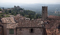 A general view of Fayence | |
 Coat of arms | |
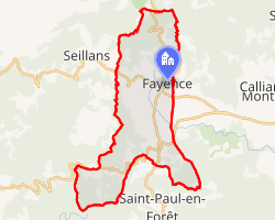 Location of Fayence | |
Fayence Fayence | |
| Coordinates: 43°37′27″N 6°41′41″E / 43.6242°N 6.6947°E / 43.6242; 6.6947 | |
| Country | France |
| Region | Provence-Alpes-Côte d'Azur |
| Department | Var |
| Arrondissement | Draguignan |
| Canton | Roquebrune-sur-Argens |
| Intercommunality | Pays de Fayence |
| Government | |
| • Mayor (2020–2026) | Bernard Henry1 |
Area 1 | 27.68 km2 (10.69 sq mi) |
| Population (2023)2 | 6,157 |
| • Density | 222.4/km2 (576.1/sq mi) |
| Time zone | UTC+01:00 (CET) |
| • Summer (DST) | UTC+02:00 (CEST) |
| INSEE/Postal code | 83055 /83440 |
| Elevation | 184–665 m (604–2,182 ft) (avg. 349 m or 1,145 ft) |
| 1 French Land Register data, which excludes lakes, ponds, glaciers > 1 km2 (0.386 sq mi or 247 acres) and river estuaries. | |
Fayence (French pronunciation: [fajɑ̃s]; Occitan: Faiença) is a commune in the Var department in the Provence-Alpes-Côte d'Azur region in Southeastern France.
Fayence is one of a series of "perched villages" overlooking the plain between the southern Alps and the Esterel massif, which borders the Mediterranean Sea between Cannes and Saint-Raphaël. The village is located on the road to Mons, which later on joins the Route Napoléon linking Nice to Grenoble through the Alps.
Some high-standing resorts have settled nearby the village in the recent years: the Domaine de Terre Blanche at Tourrettes and Domaine de Fayence attract a foreign clientele. The village contains a primary school (École de la Ferrage) and a junior high school (Collège Marie Mauron).3 The Aérodrome de Fayence-Tourettes is one of the most active in Europe for gliding; it hosts the Provence Côte d'Azur Aeronautical Association.
History
Before and during WWII, Fayence-Tourettes Airfield was an air force base. On 13 June 1940, 12 Italian Fiat CR.42 Falcos from 151° Gruppo of 53° Stormo attacked the airfield, destroying several aircraft on the ground.456
Population
| Year | Pop. | ±% p.a. |
|---|---|---|
| 1968 | 1,768 | — |
| 1975 | 2,146 | +2.81% |
| 1982 | 2,652 | +3.07% |
| 1990 | 3,502 | +3.54% |
| 1999 | 4,253 | +2.18% |
| 2007 | 4,867 | +1.70% |
| 2012 | 5,460 | +2.33% |
| 2017 | 5,792 | +1.19% |
| 2023 | 6,157 | +1.02% |
| Source: INSEE7 | ||
Notable people
Gustave Malécot (28 December 1911–1998), mathematician
References
References
Citations
- "Répertoire national des élus: les maires" (in French). data.gouv.fr, Plateforme ouverte des données publiques françaises. 13 September 2022.
- "Populations de référence 2023" (in French). National Institute of Statistics and Economic Studies. 18 December 2025.
- Louis Boisgibault, Fahad Al Kabbani (2020): Energy Transition in Metropolises, Rural Areas and Deserts. Wiley - ISTE. (Energy series) ISBN 9781786304995.
- Skulski 2007, p. 20.
- Sgarlato 2005, p. 24.
- De Marchi 1994, p. 6.
- Population municipale entre 1968 et 2023, INSEE
Bibliography
- De Marchi, Italo. Fiat CR.42 Falco (in Italian). Modena, Italy: Stem Mucchi, 1994. No ISBN.
- Sgarlato, Nico. Fiat CR.42 (in Italian). Parma, Italy: Delta Editrice, 2005.
- Skulski, Przemysław. Fiat CR.42 Falco. Redbourn, UK: Mushroom Model Publications, 2007. ISBN 83-89450-34-8.
External links
External links
- Official site of the city of Fayence (in French)
- Photos of Fayence on photoenligne
- Photos of Fayence on Pbase
- AAPCA