Eastern Obolo
Obolo agan̄ Mbum-ura | |
|---|---|
 Interactive map of Eastern Obolo | |
| Country | |
| State | Akwa Ibom State |
| Capital | Okoroete |
| Established | 1996 |
| Government | |
| • Type | Local Government |
| • Chairman | Hon. Samuel Nteogwuijah |
| Area | |
• Total | 156.5 km2 (60.4 sq mi) |
| Elevation | 0 m (0 ft) |
| Population (2022)1 | |
• Total | 76,500 |
| • Density | 489/km2 (1,270/sq mi) |
| Time zone | UTC+1 (WAT) |
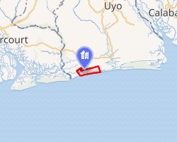
ⓘEastern Obolo (or Obolo agan̄ Mbum-ura in the native Obolo language) is a Local Government Area (LGA) in southern Nigeria, with its headquarters at Okoroete. It is a coastal local government area in Akwa-Ibom State under great tidal influence from the Bight of Bonny. Eastern Obolo LGA was mapped out of Ikot Abasi LGA by the Federal Government of Nigeria on 4 December 1996 with over 30,000 residents across a total area of approximately 17,000 km2. It comprises 16 villages, divided into two clans, namely Okoroete and Iko. It has ten political wards, of the Obolo ethnic group.23456
Climate
The climate at Obolo, which has an elevation of 0 metres/feet above sea level, is classified as tropical wet and dry or savanna (Aw). The district's average annual temperature is -0.81% lower than Nigeria's averages at 28.65 °C (83.57 °F). Obolo generally experiences 195.31 wet days (53.51% of the time) annually with average precipitation of 160.69 millimetres (6.33 inches).7
Location
Eastern Obolo is located in the Akwa ibom fringe between Imo and Qua Iboe Rivers estuaries and lies between latitudes 4° 28' and 4° 53' and longitudes 7° 50' and 7° 55' East. It is bounded to the north by Mkpat Enin Local Government Area, northeast by Onna, west by Ikot Abasi, southeast by Ibeno Local Government Area and in the south by the Atlantic Ocean.8
Culture
The Obolo have their distinct language and cultures that are unique to Obolo people in the states where they are indigenous to. Wherever the Obolo are found they have the same unique language that unites them.
Natural resources
Eastern Obolo has abundant mineral deposits9 with onshore and offshore oil wells at Elek-Okpoon̄, Iko, Otunene, Emeroke, Ikonta and Obianga. There is a fishing settlements at Educwink, Elek-Okpoon̄, Agan-asa. Forest reserves include mangrove, iroko, raffia, rubber, kolanut, coconut, peas, and mango.
Commerce
The people of Eastern Obolo are predominantly fishermen, with over 65 per cent involved in active fishing.
People
The people are a combination of Obolo ethnic group and Iko extractions; strong cultural affinity exists among the people. It has a total landmass of 117,008 square kilometres (45,177 mi2) with an estimated shoreline about 184 km long. Obolo language is the major language of the people as the different communities speak different dialects of Obolo, which are mutually intelligible. The Iko dialect spoken in Iko clan and is intelligible to a large number of people in Eastern Obolo. Iko dialect is closely related to Obolo and to the Okoroutip dialect spoken in Ibeno LGA, the sister/twin LGA of Eastern Obolo.
Population
The community population is predominantly the Obolos (80%) and Ibibio (15%), Igbo (5%) which makes up the remaining population. Emigration activities in the community is as a result of low productivity due to poor fish catch, limited farmlands, and the high rate of unemployment.
Political Wards
| Wards | Ward Centers |
| Eastern Obolo 1 | Primary School, Okoroete |
| Eastern Obolo 2 | Primary School, Okoro Mbokho |
| Eastern Obolo 3 | Primary School, Amadaka |
| Eastern Obolo 4 | Town Hall, Elekpon |
| Eastern Obolo 5 | Primary School, Emereoke |
| Eastern Obolo 6 | Primary School, Amauka |
| Eastern Obolo 7 | Primary School, Okoroinyong |
| Eastern Obolo 8 | Primary School, Iko Town |
| Eastern Obolo 9 | Primary School, Kamkpa |
| Eastern Obolo 10 | Village Square, Atabrikang |
References
References
- "Akwa Ibom State: Subdivisions". www.citypopulation.de. Retrieved 5 February 2024.
- "Coconut Oil Refinery project: A-Ibom govt assures community on compensation". Vanguard. Lagos, Nigeria. 22 March 2017. Retrieved 22 March 2017.
- "A/Ibom to compensate community in establishing coconut oil refinery". BusinessDay. 20 March 2017. Archived from the original on 23 March 2017. Retrieved 22 March 2017.
- "Ikot Abasi, Mkpat Enin, Eastern Obolo LGAs get coconut plantation, refinery". theeagleonline.com.ng. Retrieved 22 March 2017.
- Ndimele, Ozo-Mekuri (22 February 2016). Language Endangerment: Globalisation and the Fate of Minority Languages in Nigeria. M & J Grand Orbit Communications. ISBN 9789785412727.
- Ndimele, Ozo-Mekuri; Constatine, Yuka, Lendzemo (25 July 2016). Issues in Contemporary African Linguistics: A Festschrift for Oladele Awobuluyi. M & J Grand Orbit Communications. ISBN 9789785412789.
{{cite book}}: CS1 maint: multiple names: authors list (link) - "Obolo, Enugu, NG Climate Zone, Monthly Averages, Historical Weather Data". weatherandclimate.com. Retrieved 4 October 2023.
- "Eastern Obolo ( EO) | The Obolo People's Website". 21 May 2018. Archived from the original on 31 October 2020. Retrieved 13 September 2021.
- "Oil Exploration in Eastern Obolo Environment, 1996 – 2021". International Journal of History and Philosophical Research (IJHPHR). Retrieved 13 January 2024.
- Akwa Ibom State Independent Electoral Commission (2015). Political Wards In Akwa Ibom State. AKISIEC.