Drevant | |
|---|---|
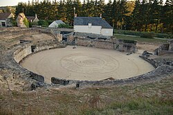 Roman amphitheatre | |
 Location of Drevant | |
Drevant Drevant | |
| Coordinates: 46°41′39″N 2°31′33″E / 46.6942°N 2.5258°E / 46.6942; 2.5258 | |
| Country | France |
| Region | Centre-Val de Loire |
| Department | Cher |
| Arrondissement | Saint-Amand-Montrond |
| Canton | Saint-Amand-Montrond |
| Intercommunality | Cœur de France |
| Government | |
| • Mayor (2020–2026) | Patrick Bigot1 |
Area 1 | 4.84 km2 (1.87 sq mi) |
| Population (2023)2 | 555 |
| • Density | 115/km2 (297/sq mi) |
| Time zone | UTC+01:00 (CET) |
| • Summer (DST) | UTC+02:00 (CEST) |
| INSEE/Postal code | 18086 /18200 |
| Elevation | 153–250 m (502–820 ft) (avg. 168 m or 551 ft) |
| 1 French Land Register data, which excludes lakes, ponds, glaciers > 1 km2 (0.386 sq mi or 247 acres) and river estuaries. | |
Drevant (French pronunciation: [dʁəvɑ̃]) is a commune in the Cher department in the Centre-Val de Loire region of France.
Geography
A farming village situated by the banks of the river Cher some 26 miles (42 km) south of Bourges at the junction of the D97 with the D141 and D2144 roads.
Population
| Year | Pop. | ±% |
|---|---|---|
| 1962 | 260 | — |
| 1968 | 283 | +8.8% |
| 1975 | 355 | +25.4% |
| 1982 | 486 | +36.9% |
| 1990 | 533 | +9.7% |
| 1999 | 610 | +14.4% |
| 2008 | 589 | −3.4% |
Sights
- The church of St. Pierre, dating from the twelfth century.
- The chapel of the eleventh-century priory.
- Considerable Gallo-Roman remains, including an amphitheatre, baths, villas and an aqueduct.
References
References
- "Répertoire national des élus: les maires" (in French). data.gouv.fr, Plateforme ouverte des données publiques françaises. 13 September 2022.
- "Populations de référence 2023" (in French). National Institute of Statistics and Economic Studies. 18 December 2025.