Dorida
Δωρίδα | |
|---|---|
 | |
Dorida | |
| Coordinates: 38°32′N 22°12′E / 38.533°N 22.200°E / 38.533; 22.200 | |
| Country | Greece |
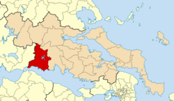
| Administrative region | Central Greece |
| Regional unit | Phocis |
| Seat | Lidoriki |
| Area | |
• Municipality | 998.9 km2 (385.7 sq mi) |
| Population (2021)1 | |
• Municipality | 12,304 |
| • Density | 12.32/km2 (31.90/sq mi) |
| Time zone | UTC+2 (EET) |
| • Summer (DST) | UTC+3 (EEST) |
Dorida (Greek: Δωρίδα) is a municipality in the Phocis regional unit of the Central Greece Region of Greece. The seat of the municipality is the town Lidoriki.2 It has an area of 998.893 km23 and a population of 12,304.1
Etymology
Dorida is named after the ancient region of Doris, which was inhabited by the Dorians.4 According to ancient Greek mythology, the name is derived from Dorus, a son of Hellen and the founder of the Dorian nation.5
Municipality
The municipality Dorida was formed at the 2011 local government reform by the merger of the following 4 former municipalities, that became municipal units:2
Province
The province of Dorida (Greek: Επαρχία Δωρίδας) was one of the provinces of Phocis. It had the same territory as the present municipality.6 It was abolished in 2006.
References
References
- "Αποτελέσματα Απογραφής Πληθυσμού - Κατοικιών 2021, Μόνιμος Πληθυσμός κατά οικισμό" [Results of the 2021 Population - Housing Census, Permanent population by settlement] (in Greek). Hellenic Statistical Authority. 29 March 2024.
- "ΦΕΚ A 87/2010, Kallikratis reform law text" (in Greek). Government Gazette.
- "Population & housing census 2001 (incl. area and average elevation)" (PDF) (in Greek). National Statistical Service of Greece. Archived from the original (PDF) on 2015-09-21.
- "Ιστορία της Δώριδας". www.visitdorida.gr. Retrieved 15 July 2025.
- Apollodorus, 1.7.3
- "Detailed census results 1991" (PDF). Archived from the original (PDF) on 2016-03-03. (39 MB) (in Greek and French)