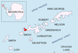

Dometa Point (Bulgarian: нос Домета, ‘Nos Dometa’ \'nos do-'me-ta\) is a point in the middle part of South Beaches on Byers Peninsula, Livingston Island in the South Shetland Islands, Antarctica. It is situated 4.3 km west-northwest of Rish Point, 1.2 km southwest of Negro Hill, 4.6 km southeast of Chester Cone, and 4.2 km east-northeast of Nikopol Point. Fontus Lake is centred 600 m northeast of the point.
The feature is named after Dometa, governor of the southwestern Bulgarian province of Kutmichevitsa hosting the mission of St. Kliment Ohridski assigned by Czar Boris I of Bulgaria (9th Century AD).
Location
Dometa Point is located at 62°39′44″S 61°00′51″W / 62.66222°S 61.01417°W / -62.66222; -61.01417 (British mapping in 1968, detailed Spanish mapping in 1992, and Bulgarian mapping in 2005 and 2009).
Map
- Península Byers, Isla Livingston. Mapa topográfico a escala 1:25000. Madrid: Servicio Geográfico del Ejército, 1992.
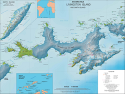
- L.L. Ivanov et al. Antarctica: Livingston Island and Greenwich Island, South Shetland Islands. Scale 1:100000 topographic map. Sofia: Antarctic Place-names Commission of Bulgaria, 2005.
- L.L. Ivanov. Antarctica: Livingston Island and Greenwich, Robert, Snow and Smith Islands. Scale 1:120000 topographic map. Troyan: Manfred Wörner Foundation, 2010. ISBN 978-954-92032-9-5 (First edition 2009. ISBN 978-954-92032-6-4)
- Antarctic Digital Database (ADD). Scale 1:250000 topographic map of Antarctica. Scientific Committee on Antarctic Research (SCAR). Since 1993, regularly upgraded and updated.
- L.L. Ivanov. Antarctica: Livingston Island and Smith Island. Scale 1:100000 topographic map. Manfred Wörner Foundation, 2017. ISBN 978-619-90008-3-0
References
References
- Dometa Point. SCAR Composite Gazetteer of Antarctica.
- Bulgarian Antarctic Gazetteer. Antarctic Place-names Commission. (details in Bulgarian, basic data in English)
External links
External links
- Dometa Point. Copernix satellite image
This article includes information from the Antarctic Place-names Commission of Bulgaria which is used with permission.