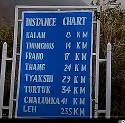
Thang
Dhothang, Thanga Chathang | |
|---|---|
Village | |
Thang Thang | |
| Coordinates: 34°55′34″N 76°47′42″E / 34.926°N 76.795°E / 34.926; 76.795 | |
| Country | |
| Union Territory | Ladakh |
| District | Nubra |
| Tehsil | Nubra |
| Population (2011) | |
• Total | 103 |
| Time zone | UTC+5:30 (IST) |
| PIN | 194401 |
| Census code | 911 |
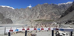
Thang (also called Dhothang, Thanga Chathang) is a small village in the Nubra district of Ladakh, India.1 It is in the historical Chorbat region of Baltistan, divided between India and Pakistan by the 1972 Line of Control. Thang is part of the Nubra tehsil and the Turtuk community development block. It is twinned with the village of Frano, Gilgit-Baltistan.
The village was seized from Pakistan along with three other villages in the area as a result of the Indo-Pakistani War of 1971. It is 2.5 kilometers from the Line of Control.2 The area's population is largely Balti.3
History
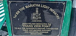
See history of Turtuk and nearby areas.
Demographics
According to the 2011 census of India, Thang had 16 households in that year. The effective literacy rate (i.e. the literacy rate of population excluding children aged 6 and below) was 63.41%.14
| Total | Male | Female | |
|---|---|---|---|
| Population | 103 | 53 | 50 |
| Children aged below 6 years | 21 | 11 | 10 |
| Scheduled caste | 0 | 0 | 0 |
| Scheduled tribe | 88 | 45 | 43 |
| Literates | 52 | 27 | 25 |
| Workers (all) | 48 | 25 | 23 |
| Main workers (total) | 36 | 19 | 17 |
| Main workers: Cultivators | 34 | 18 | 16 |
| Main workers: Agricultural labourers | 0 | 0 | 0 |
| Main workers: Household industry workers | 0 | 0 | 0 |
| Main workers: Other | 2 | 1 | 1 |
| Marginal workers (total) | 12 | 6 | 6 |
| Marginal workers: Cultivators | 5 | 3 | 2 |
| Marginal workers: Agricultural labourers | 0 | 0 | 0 |
| Marginal workers: Household industry workers | 1 | 0 | 1 |
| Marginal workers: Others | 6 | 3 | 3 |
| Non-workers | 55 | 28 | 27 |
References
References
- "Blockwise Village Amenity Directory" (PDF). Ladakh Autonomous Hill Development Council. Retrieved 23 July 2015.
- "Turtuk, a Promised Land Between Two Hostile Neighbours". The Wire.
- "Exploring the breathtaking landscapes of Indo-Pak border". Hindustan Times. 15 March 2015.
- "Leh district census". 2011 Census of India. Directorate of Census Operations. Retrieved 23 July 2015.
External links
External links
- Jitaditya Narzary, Thang, That Village Beyond the LOC, Travelling Slacker (blog), 31 July 2019.