Connello Lower
Conallaigh Íochtaracha (Irish) | |
|---|---|
 The River Deel near Rathkeale | |
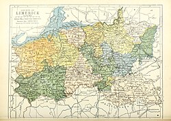 Barony map of County Limerick, 1900; Connello Lower is in the northwest, coloured yellow. | |
Connello Lower | |
| Coordinates: 52°32′N 8°58′W / 52.54°N 8.96°W / 52.54; -8.96 | |
| Sovereign state | Ireland |
| Province | Munster |
| County | Limerick |
| Area | |
• Total | 193.6 km2 (74.7 sq mi) |
Connello Lower (Irish: Conallaigh Íochtaracha; sometimes Lower Connello,1 and occasionally spelled Conello)2 is a historical barony in northwest County Limerick, Ireland.345
Baronies were mainly cadastral rather than administrative units.6 They acquired modest local taxation and spending functions in the 19th century before being superseded by the Local Government (Ireland) Act 1898.78
History
Originally western Limerick was a single vast barony known as Connello.910 It was divided into Lower (northern) and Upper (southern) halves some time before 1821, and 1841 the western part of Connello Lower was made a separate barony, Shanid, while the western half of Connello Upper became the barony of Glenquin.11
The Connello Lower region was the anciently the possession of the Uí Chonaill Gabra, part of the Uí Fidgeinti; the name refers to an ancestor, Conall Gabra, "Conall of the White Horse."12 The Connalla was the name of the Eóganachta cantred. The Ó Coileáin (Collins or Cullane) were lords of Connello until they moved to County Cork in the 13th century.13
Geography
Connello Lower is in the northwest of the county, south of the Shannon Estuary and incorporating the lower part of the River Deel's basin.14
List of settlements
Settlements within the historical barony of Connello Lower include:1516
References
References
- "O'Collins Lords of Lower Connello, County Limerick". 10 July 2016.
- Hanley, Vincent (17 October 2017). "Early Divisions in Ireland – The Origins of our Counties, Baronies, Parishes and Townlands".
- "Connello Lower". www.townlands.ie.
- The Parliamentary Gazetteer of Ireland: Adapted to the New Poor-law, Franchise, Municipal and Ecclesiastical Arrangements, and Compiled with a Special Reference to the Lines of Railroad and Canal Communication, as Existing in 1814-45. (1846:215–6). Ireland: A. Fullarton and Company.
- "Connello Lower". www.townlands.ie.
- "CoshleaBarony | Landed Estates | University of Galway". landedestates.ie.
- General Register Office of Ireland (1904). "Alphabetical index to the baronies of Ireland". Census of Ireland 1901: General topographical index. Command papers. Vol. Cd. 2071. HMSO. pp. 966–978.
- Office, Ireland Public Record (12 February 1891). "Report of the Deputy Keeper of the Public Records and of the Keeper of the State Papers in Ireland: Presented to Both Houses of the Oireachtas". Stationery Office. – via Google Books.
- Kenney, J. F. (1966:389). The Sources for the Early History of Ireland: Ecclesiastical: An Introduction and Guide. Ireland: Octagon Books.
- "Ui Conaill Gabhra - Irish Names and Surnames". www.libraryireland.com.
- Wyndham-Quin, Caroline; Edwin Richard W. Wyndham-Quin (1865). Memorials of Adare manor; with historical notices of Adare. Oxford: privately printed by Messrs Parker. pp. 277.
- "eDIL - Irish Language Dictionary". dil.ie.
- "The Baronies of Ireland - History". 17 July 2019. Archived from the original on 17 July 2019.
- "Connello Lower Barony | Landed Estates | University of Galway". landedestates.ie.
- "Sub-units of: Conallaigh Íochtaracha/Connello Lower". logainm.ie.
- https://www.genuki.org.uk/big/irl/LIM/land/ConnelloBarony