Combles | |
|---|---|
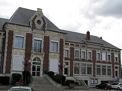 The town hall in Combles | |
 Coat of arms | |
 Location of Combles | |
Combles Combles | |
| Coordinates: 50°00′36″N 2°51′58″E / 50.01°N 2.8661°E / 50.01; 2.8661 | |
| Country | France |
| Region | Hauts-de-France |
| Department | Somme |
| Arrondissement | Péronne |
| Canton | Péronne |
| Intercommunality | Haute Somme |
| Government | |
| • Mayor (2020–2026) | Betty Sorel1 |
Area 1 | 9.87 km2 (3.81 sq mi) |
| Population (2023)2 | 757 |
| • Density | 76.7/km2 (199/sq mi) |
| Time zone | UTC+01:00 (CET) |
| • Summer (DST) | UTC+02:00 (CEST) |
| INSEE/Postal code | 80204 /80360 |
| Elevation | 83–153 m (272–502 ft) (avg. 30 m or 98 ft) |
| 1 French Land Register data, which excludes lakes, ponds, glaciers > 1 km2 (0.386 sq mi or 247 acres) and river estuaries. | |
Combles (French pronunciation: [kɔ̃bl] ⓘ; Picard: Conme) is a commune in the Somme department in Hauts-de-France in northern France. The city is part of the First World War remembrance circuit.
Geography
Combles is situated on the D20 road, some 50 km (31 mi) north-east of Amiens.
History

Combles was the operations centre for the battle of Bapaume during the Franco-Prussian War of 1870–71.
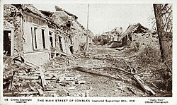
Combles was again at the centre of much fighting during World War I (1914–1918), with many of its buildings damaged and many of its residents injured or killed, not to mention the numerous casualties among the forces in combat there. Many British soldiers who fell in the war are buried in the local cemetery, and there are numerous war cemeteries in the immediate surrounding area.
It has, however, been substantially developed since the war's end.
Population
| Year | Pop. | ±% p.a. |
|---|---|---|
| 1968 | 691 | — |
| 1975 | 661 | −0.63% |
| 1982 | 648 | −0.28% |
| 1990 | 617 | −0.61% |
| 1999 | 676 | +1.02% |
| 2007 | 707 | +0.56% |
| 2012 | 795 | +2.37% |
| 2017 | 765 | −0.77% |
| 2023 | 757 | −0.18% |
| Source: INSEE3 | ||
References
References
- "Répertoire national des élus: les maires". data.gouv.fr, Plateforme ouverte des données publiques françaises (in French). 2 December 2020.
- "Populations de référence 2023" (in French). National Institute of Statistics and Economic Studies. 18 December 2025.
- Population municipale entre 1968 et 2023, INSEE