Cimego | |
|---|---|
| Comune di Cimego | |
Cimego Location of Cimego in Italy Show map of ItalyCimego Cimego (Trentino-Alto Adige/Südtirol) Show map of Trentino-Alto Adige/Südtirol | |
| Coordinates: 45°55′N 10°37′E / 45.917°N 10.617°E / 45.917; 10.617 | |
| Country | Italy |
| Region | Trentino-Alto Adige/Südtirol |
| Province | Trentino (TN) |
| Area | |
• Total | 10.5 km2 (4.1 sq mi) |
| Population (Dec. 2004) | |
• Total | 418 |
| • Density | 39.8/km2 (103/sq mi) |
| Time zone | UTC+1 (CET) |
| • Summer (DST) | UTC+2 (CEST) |
| Postal code | 38082 |
| Dialing code | 0465 |
| Website | Official website |
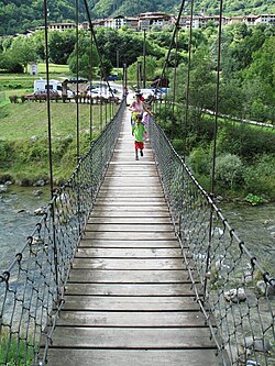
Cimego (German: Zimeck) is a former comune, now a frazione of Borgo Chiese2 in Trentino in the northern Italian region Trentino-Alto Adige/Südtirol, located about 40 kilometres (25 mi) southwest of Trento. As of 31 December 2004, it had a population of 418 and an area of 10.5 square kilometres (4.1 mi2).3
Cimego borders the following municipalities: Daone, Pieve di Bono, Condino, Castel Condino and Ledro.
Demographic evolution
Historical population | |||||||||||||||||||||||||||||||||||||||||||||||||||||
|
|
| |||||||||||||||||||||||||||||||||||||||||||||||||||
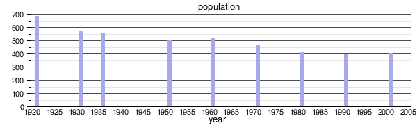 | |||||||||||||||||||||||||||||||||||||||||||||||||||||
| Source: Data from ISTAT | |||||||||||||||||||||||||||||||||||||||||||||||||||||
References
References
- "Superficie di Comuni Province e Regioni italiane al 9 ottobre 2011". Italian National Institute of Statistics. Retrieved 16 March 2019.
- "Comune di Borgo Chiese".
- All demographics and other statistics: Italian statistical institute Istat.