| Zhuoshui River | |
|---|---|
 | |
 | |
| Native name | 濁水溪 (Chinese) |
| Location | |
| Country | Republic of China |
| Province | Taiwan |
| Counties | Changhua, Chiayi, Nantou, Yunlin |
| Physical characteristics | |
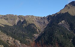
| Source | Wushe River (霧社溪) |
| • location | Hehuanshan East Peak, Nantou County |
| Mouth | |
• location | Between Changhua County and Yunlin County |
• coordinates | 23°50′26″N 120°14′19″E / 23.84056°N 120.23861°E / 23.84056; 120.23861 |
| Length | 203 km (126 mi) |
Basin size | 3,155.21 km2 (1,218.23 sq mi) |
| Discharge | |
| • average | 164.8 m3/s (5,820 cu ft/s) |
| • maximum | 14,000 m3/s (490,000 cu ft/s) |
| Basin features | |
| Tributaries | |
| • left | Chingshui River, Chenyoulan River, Kashe River, and others |
| • right | Shuili River, and others |
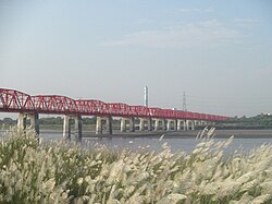
| Bridges | Xiluo Bridge |
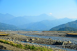
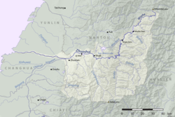
The Zhuoshui River (Chinese: 濁水溪a), also spelled Choshui or Jhuoshuei River, is the longest river in Taiwan,1 with a total length of 203 km (126 mi).2 It flows from its source in Nantou County up to the western border of the county, subsequently forming the border between Yunlin County and Changhua County. The river serves as an unofficial boundary between the north and south of Taiwan.345
The river is dammed in its upper reaches by the Wushe and Wujie Dams, and further downstream by the Jiji Weir. In recent years, the environment surrounding the river has been seriously degraded both by the construction of a dam across the river at Jiji and by the ongoing activities of the concrete industry.
Tributaries
Bridges
Dams
References
References
- "Geography & demographics". The Republic of China Yearbook 2015. Executive Yuan. 2015. pp. 40–53. ISBN 978-986-04-6013-1.
- 讓我們看河去(重要河川)-- 濁水溪 (in Chinese). Water Resources Agency, Ministry of Economic Affairs (Republic of China). Archived from the original on December 24, 2013. Retrieved February 4, 2011.
- Gao, Pat (November 1, 2007). "Taiwan's Marginalized South". Taiwan Review. Government Information Office, Republic of China (Taiwan). Retrieved November 12, 2010.
- "President Tsai unveils growth roadmap for southern Taiwan". Focus Taiwan. 2019-12-14. Retrieved 2019-12-21.
- "2020 Elections: Tsai unveils 'great south' plan on development gap". Taipei Times. 2019-12-15. Retrieved 2019-12-21.
- Hanyu Pinyin: Zhuóshuǐ Xī; Tongyong Pinyin: Jhuóshuěi Si; Wade–Giles: Cho2-shui3 Hsi1; Pe̍h-ōe-jī: Lô-chúi-khoe
Further reading
Further reading
- Shaw, Rajib; Thaitakoo, Danai, eds. (10 Jun 2010). "Chapter 13 The Water Community Case of Chou-Shui River in Taiwan". Water Communities : Community, Environment and Disaster Risk Management : Volume 2. Emerald Group Publishing Limited. pp. 241–262. ISBN 978-1849506984. Retrieved 1 February 2015.