Chewko | |||||||||||||
|---|---|---|---|---|---|---|---|---|---|---|---|---|---|
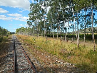 Chewko, along the Tablelands railway line, 2013 | |||||||||||||
Chewko | |||||||||||||
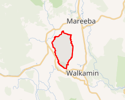 Interactive map of Chewko | |||||||||||||
| Coordinates: 17°04′16″S 145°22′12″E / 17.0711°S 145.37°E / -17.0711; 145.37 (Chewko (centre of locality)) | |||||||||||||
| Country | Australia | ||||||||||||
| State | Queensland | ||||||||||||
| LGA | |||||||||||||
| Location |
| ||||||||||||
| Government | |||||||||||||
| • State electorates | |||||||||||||
| • Federal division | |||||||||||||
| Area | |||||||||||||
• Total | 42.2 km2 (16.3 sq mi) | ||||||||||||
| Population | |||||||||||||
| • Total | 213 (2021 census)2 | ||||||||||||
| • Density | 5.047/km2 (13.07/sq mi) | ||||||||||||
| Time zone | UTC+10:00 (AEST) | ||||||||||||
| Postcode | 4880 | ||||||||||||
| |||||||||||||
Chewko is a rural locality in the Shire of Mareeba, Queensland, Australia.3 In the 2021 census, Chewko had a population of 213 people.2
Geography
Chewko has the following mountains:
- Mount Abbot (17°02′08″S 145°22′35″E / 17.0355°S 145.3763°E / -17.0355; 145.3763 (Mount Abbot)) 601 metres (1,972 ft)45
- Mount Aunt (17°05′24″S 145°23′12″E / 17.0901°S 145.3868°E / -17.0901; 145.3868 (Mount Aunt)) 765 metres (2,510 ft)46
- Mount Uncle (17°06′32″S 145°22′39″E / 17.1090°S 145.3774°E / -17.1090; 145.3774 (Mount Uncle)) 754 metres (2,474 ft)47
Chewko railway station is on the Tablelands railway line (17°04′24″S 145°22′26″E / 17.0734°S 145.3740°E / -17.0734; 145.3740 (Chewko railway station)).8
Demographics
In the 2016 census Chewko had a population of 194 people.9
In the 2021 census, Chewko had a population of 213 people.2
Education
There are no schools in Chewko. The nearest government primary schools are Mareeba State School in neighbouring Mareeba to the north-east and Walkamin State School in neighbouring Walkamin to the south-east. The nearest government secondary school is Mareeba State High School in Mareeba.10
Attractions
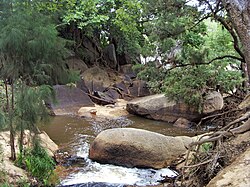
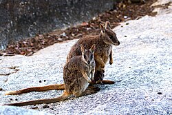
Granite Gorge Nature Park is known for its large granite rock formations and Mareeba rock wallabies.1112 It is at 332 Paglietta Road (17°02′32″S 145°21′04″E / 17.0421°S 145.3512°E / -17.0421; 145.3512 (Granite Gorge Nature Park)).13
References
References
- Australian Bureau of Statistics (28 June 2022). "Chewko (suburb and locality)". Australian Census 2021 QuickStats. Retrieved 28 June 2022.
- Australian Bureau of Statistics (28 June 2022). "Chewko (SAL)". 2021 Census QuickStats. Retrieved 28 February 2023.
- "Chewko – locality in Shire of Mareeba (entry 48569)". Queensland Place Names. Queensland Government. Retrieved 28 December 2020.
- "Mountain peaks and capes - Queensland". Queensland Open Data. Queensland Government. 12 November 2020. Archived from the original on 25 November 2020. Retrieved 25 November 2020.
- "Mount Abbot – mountain in Mareeba Shire (entry 17)". Queensland Place Names. Queensland Government. Retrieved 25 November 2020.
- "Mount Aunt – mountain in Mareeba Shire (entry 1019)". Queensland Place Names. Queensland Government. Retrieved 25 November 2020.
- "Mount Uncle – mountain in Mareeba Shire (entry 35781)". Queensland Place Names. Queensland Government. Retrieved 25 November 2020.
- "Railway stations and sidings - Queensland". Queensland Open Data. Queensland Government. 2 October 2020. Archived from the original on 5 October 2020. Retrieved 5 October 2020.
- Australian Bureau of Statistics (27 June 2017). "Chewko (SSC)". 2016 Census QuickStats. Retrieved 20 October 2018.
- "Layers: Locality; Schools and school catchments". Queensland Globe. Queensland Government. Archived from the original on 19 December 2017. Retrieved 30 June 2024.
- "Granite Gorge". 11 November 2023. Archived from the original on 25 February 2024. Retrieved 30 June 2024.
- "Mareeba Rock Wallaby". 11 November 2023. Archived from the original on 25 February 2024. Retrieved 30 June 2024.
- "Granite Gorge Nature Park". Archived from the original on 17 April 2024. Retrieved 30 June 2024.