Chavenay | |
|---|---|
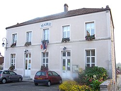 The town hall in Chavenay | |
 Coat of arms | |
 Location of Chavenay | |
Chavenay Chavenay | |
| Coordinates: 48°51′16″N 1°59′14″E / 48.8544°N 1.9872°E / 48.8544; 1.9872 | |
| Country | France |
| Region | Île-de-France |
| Department | Yvelines |
| Arrondissement | Saint-Germain-en-Laye |
| Canton | Saint-Cyr-l'École |
| Government | |
| • Mayor (2020–2026) | Myriam Brenac1 |
Area 1 | 6.03 km2 (2.33 sq mi) |
| Population (2023)2 | 1,723 |
| • Density | 286/km2 (740/sq mi) |
| Time zone | UTC+01:00 (CET) |
| • Summer (DST) | UTC+02:00 (CEST) |
| INSEE/Postal code | 78152 /78450 |
| Elevation | 71–129 m (233–423 ft) (avg. 100 m or 330 ft) |
| 1 French Land Register data, which excludes lakes, ponds, glaciers > 1 km2 (0.386 sq mi or 247 acres) and river estuaries. | |
Chavenay (French pronunciation: [ʃavnɛ] ⓘ), also known as Vallon de Chavenay, is a commune in the Yvelines department in the Île-de-France region in north-central France. It is located close to Saint-Nom-la-Bretèche, Saint-Germain-en-Laye, and Versailles.

Twin towns
Along with Crespières, Feucherolles and Saint-Nom-la-Bretèche Chavenay is twinned with Rösrath, Germany.
References
References
- "Répertoire national des élus: les maires" (in French). data.gouv.fr, Plateforme ouverte des données publiques françaises. 4 May 2022.
- "Populations de référence 2023" (in French). National Institute of Statistics and Economic Studies. 18 December 2025.