Chancelade | |
|---|---|
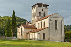 The abbey in Chancelade | |
 Location of Chancelade | |
Chancelade Chancelade | |
| Coordinates: 45°12′23″N 0°39′58″E / 45.2064°N 0.6661°E / 45.2064; 0.6661 | |
| Country | France |
| Region | Nouvelle-Aquitaine |
| Department | Dordogne |
| Arrondissement | Périgueux |
| Canton | Coulounieix-Chamiers |
| Intercommunality | Le Grand Périgueux |
| Government | |
| • Mayor (2020–2026) | Pascal Serre1 |
Area 1 | 16.23 km2 (6.27 sq mi) |
| Population (2023)2 | 4,468 |
| • Density | 275.3/km2 (713.0/sq mi) |
| Time zone | UTC+01:00 (CET) |
| • Summer (DST) | UTC+02:00 (CEST) |
| INSEE/Postal code | 24102 /24650 |
| Elevation | 73–198 m (240–650 ft) |
| 1 French Land Register data, which excludes lakes, ponds, glaciers > 1 km2 (0.386 sq mi or 247 acres) and river estuaries. | |
Chancelade (French pronunciation: [ʃɑ̃slad]; Occitan: Chancelada) is a commune in the Dordogne department in Nouvelle-Aquitaine in southwestern France. The village is the site of Chancelade Abbey.
The so-called "Chancelade man" was found in the nearby Raymonden rock shelter in 1888, the skeleton of an approximately 60-year-old male who was buried there in the Magdalenian, roughly 15,000 years ago.
Population
Historical population | ||||||||||||||||||||||||||||||||||||||||||||||||||||||||||||||||||||||||||||||||||||||||||||||||||||||||||||||||||||||
|
| |||||||||||||||||||||||||||||||||||||||||||||||||||||||||||||||||||||||||||||||||||||||||||||||||||||||||||||||||||||
| Source: EHESS3 and INSEE (1968-2023)4 | ||||||||||||||||||||||||||||||||||||||||||||||||||||||||||||||||||||||||||||||||||||||||||||||||||||||||||||||||||||||
References
References
- "Répertoire national des élus: les maires" (in French). data.gouv.fr, Plateforme ouverte des données publiques françaises. 13 September 2022.
- "Populations de référence 2023" (in French). National Institute of Statistics and Economic Studies. 18 December 2025.
- Des villages de Cassini aux communes d'aujourd'hui: Commune data sheet Chancelade, EHESS (in French).
- Population municipale entre 1968 et 2023, INSEE