Cattenom | |
|---|---|
 Nuclear power plant | |
 Coat of arms | |
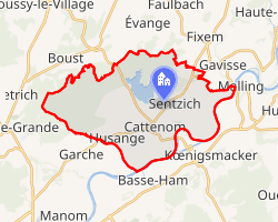 Location of Cattenom | |
Cattenom Cattenom | |
| Coordinates: 49°25′00″N 6°15′00″E / 49.4167°N 6.250000°E / 49.4167; 6.250000 | |
| Country | France |
| Region | Grand Est |
| Department | Moselle |
| Arrondissement | Thionville |
| Canton | Yutz |
| Intercommunality | Cattenom et Environs |
| Government | |
| • Mayor (2020–2026) | Bernard Zenner1 |
Area 1 | 25.47 km2 (9.83 sq mi) |
| Population (2023)2 | 2,580 |
| • Density | 101/km2 (262/sq mi) |
| Time zone | UTC+01:00 (CET) |
| • Summer (DST) | UTC+02:00 (CEST) |
| INSEE/Postal code | 57124 /57570 |
| 1 French Land Register data, which excludes lakes, ponds, glaciers > 1 km2 (0.386 sq mi or 247 acres) and river estuaries. | |
Cattenom (French pronunciation: [katnɔm]; Luxembourgish: Kettenuewen; German: Kattenhofen) is a commune in the Moselle department in Grand Est in north-eastern France.
Geography
It lies about 8 kilometres north of Thionville. The localities of Homeldange, Husange (aka Hussange) and Sentzich are incorporated in the commune.
Population
| Year | Pop. | ±% p.a. |
|---|---|---|
| 1968 | 1,851 | — |
| 1975 | 2,374 | +3.62% |
| 1982 | 2,209 | −1.02% |
| 1990 | 2,190 | −0.11% |
| 1999 | 2,272 | +0.41% |
| 2007 | 2,549 | +1.45% |
| 2012 | 2,749 | +1.52% |
| 2017 | 2,654 | −0.70% |
| 2023 | 2,580 | −0.47% |
| Source: INSEE3 | ||
Toponymy
Former names:4 Cathenem (1182), Kettenem (1214), Kettenhem (1329), Kettenheim (1400), Kerthenhem (1426), Katenem (1432), Kettenheim (1481), Keluchem / Ketenhon / Cetenhem / Kentuchen / Kettenoffen (1544), Kettenhoven (1568-1570), Cettenhouen (1589), Kattenhous (1594), Catnum (16th century), Katenom (1668), Catnom (1685), Kethenoven (1686), Cattenom (1793).
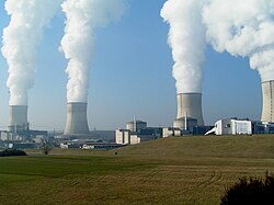
Nuclear power station
Cattenom is well known for its nuclear power plant, which was built from 1987 to 1992. An artificial lake has been introduced to cool the four nuclear reactors. The creation of this lake has led to the flooding of Ouvrage Kobenbusch, part of the Maginot Line.
References
References
- "Répertoire national des élus: les maires" (in French). data.gouv.fr, Plateforme ouverte des données publiques françaises. 13 September 2022.
- "Populations de référence 2023" (in French). National Institute of Statistics and Economic Studies. 18 December 2025.
- Population municipale entre 1968 et 2023, INSEE
- de Bouteille, Ernest (1868). Dictionnaire topographique de l'ancien département de la Moselle (in French). Paris: Imprimerie impériale.
External links
External links
- Official website Archived 8 March 2021 at the Wayback Machine (in French)