Canda | |
|---|---|
| Comune di Canda | |
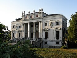 Villa Nani Mocenigo | |
Canda Location of Canda in Italy Show map of ItalyCanda Canda (Veneto) Show map of Veneto | |
| Coordinates: 45°2′N 11°31′E / 45.033°N 11.517°E / 45.033; 11.517 | |
| Country | Italy |
| Region | Veneto |
| Province | Province of Rovigo (RO) |
| Frazioni | La Chiavica, Le Campagnole |
| Area | |
• Total | 14.4 km2 (5.6 sq mi) |
| Elevation | 9 m (30 ft) |
| Population (Apr.2017)2 | |
• Total | 900 |
| • Density | 62/km2 (160/sq mi) |
| Time zone | UTC+1 (CET) |
| • Summer (DST) | UTC+2 (CEST) |
| Dialing code | 0425 |
Canda is a comune (municipality) in the Province of Rovigo in the Italian region Veneto, located about 80 km (50 mi) southwest of Venice and about 20 kilometres (12 mi) west of Rovigo. As of 31 December 2004, it had a population of 958 and an area of 14.4 square kilometres (5.6 mi2).3
The municipality of Canda contains the frazioni (subdivisions, mainly villages and hamlets) La Chiavica and Le Campagnole.
Canda borders the following municipalities: Badia Polesine, Bagnolo di Po, Castelguglielmo, Lendinara, Trecenta.
Demographic evolution
Historical population | |||||||||||||||||||||||||||||||||||||||||||||||||||||
|
|
| |||||||||||||||||||||||||||||||||||||||||||||||||||
 | |||||||||||||||||||||||||||||||||||||||||||||||||||||
| Source: Data from ISTAT | |||||||||||||||||||||||||||||||||||||||||||||||||||||
References
References
- "Superficie di Comuni Province e Regioni italiane al 9 ottobre 2011". Italian National Institute of Statistics. Retrieved 16 March 2019.
- "Popolazione Residente al 1° Gennaio 2018". Italian National Institute of Statistics. Retrieved 16 March 2019.
- All demographics and other statistics: Italian statistical institute Istat.