Caineville, Utah | |
|---|---|
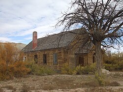 Abandoned former church/schoolhouse | |
Caineville, Utah Caineville, Utah (the United States) Show map of the United States | |
| Coordinates: 38°19′59″N 111°01′08″W / 38.33306°N 111.01889°W / 38.33306; -111.01889 | |
| Country | United States |
| State | Utah |
| County | Wayne |
| Settled | 1882 |
| Founded by | Elijah Cutler Behunin |
| Named after | John T. Caine |
| Elevation | 4,600 ft (1,400 m) |
| Time zone | UTC-7 (Mountain (MST)) |
| • Summer (DST) | UTC-6 (MDT) |
| ZIP code | 84775 |
| Area code | 435 |
| GNIS feature ID | 14262691 |
Caineville is an unincorporated community in central Wayne County, Utah, United States.1
The community is located east of Capitol Reef National Park and west of Hanksville, along the Fremont River and Utah State Route 24. The settlement was named after John T. Caine2 and was founded by Elijah Cutler Behunin, whom the LDS Church sent there in 1882 to open the area for settlement.3
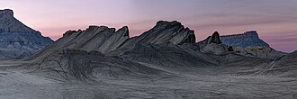
Swing Arm City is a 2,600-acre off-highway vehicle area near Caineville.4
Demographics
| Census | Pop. | Note | %± |
|---|---|---|---|
| 1900 | 131 | — | |
| 1910 | 38 | −71.0% | |
| 1920 | 67 | 76.3% | |
| 1930 | 71 | 6.0% | |
| 1940 | 68 | −4.2% | |
| 1950 | 20 | −70.6% | |
| Source: U.S. Census Bureau5 | |||
References
References
- "Caineville". Geographic Names Information System. United States Geological Survey, United States Department of the Interior.
- Hunt, Charles B.; Averitt, Paul; Miller, Ralph L. (1953). "Geology and Geography of the Henry Mountains Region, Utah". Professional Paper (228). United States Geological Survey: 21.
{{cite journal}}: Cite journal requires|journal=(help) - Van Cott, John W. (1990). Utah Place Names: A Comprehensive Guide to the Origins of Geographic Names: A Compilation. Salt Lake City: University of Utah Press. pp. 61–62. ISBN 978-0-87480-345-7. OCLC 797284427. Retrieved 9 Feb 2018.
- Ambrose Martos (25 February 2020). "Where You Can Motocross Utah's Biggest Natural Jumps and Ridgeline Singletrack". Men's Journal.
- "Census of Population and Housing". United States Census Bureau. Archived from the original on 8 February 2006. Retrieved 18 Nov 2011.