Brookby | |
|---|---|
Locality | |
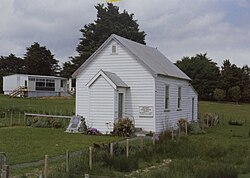 Brookby Unsectarian Church, built in 1878 | |
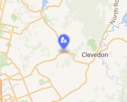 Interactive map of Brookby | |
| Coordinates: 36°59′13″S 174°59′40″E / 36.9870°S 174.9945°E / -36.9870; 174.9945 | |
| Country | New Zealand |
| Council | Auckland Council |
| Electoral Ward | Franklin Ward |
| Local board | Franklin Local Board |
| Electorates |
|
| Government | |
| • Territorial Authority | Auckland Council |
| • Mayor of Auckland | Wayne Brown1 |
| • Papakura MP | Vacant |
| • Hauraki-Waikato MP | Hana-Rawhiti Maipi-Clarke2 |
| Area | |
• Total | 336 ha (830 acres) |
| Population (2023) | |
• Total | 129 |
| • Density | 38.4/km2 (99.4/sq mi) |
| Whitford | ||
|
|
Clevedon | |
| Alfriston, Ardmore |
Brookby is a rural settlement, south of Auckland, New Zealand. Brookby is approximately 5 kilometres west of Clevedon and 5 km southeast of Whitford.
The original post-office was located near a Brook (Papakura Stream), and so was named by the brook, or Brookby.3
Notable places
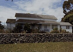
Meadowbrook is the oldest extant home in the area. Meadowbrook was constructed by a Mr Lord in 1880 from locally milled kauri. The property also features a 26 m (85 ft) well.4
Brookby Unsectarian Church is an 1878 Church that served as the centre of the community at Brookby.The Church contains a memorial stone to John and Leah Embling, who settled in Brookby in 1854.4
Demographics
Brookby is in an SA1 statistical area which covers 3.36 km2 (1.30 sq mi).5 The SA1 area is part of the larger Turanga statistical area.6
| Year | Pop. | ±% p.a. |
|---|---|---|
| 2006 | 186 | — |
| 2013 | 117 | −6.41% |
| 2018 | 123 | +1.01% |
| 2023 | 129 | +0.96% |
| The 2006 population is for a larger area of 8.25 km2. Source: 78 | ||
The SA1 statistical area had a population of 129 in the 2023 New Zealand census, an increase of 6 people (4.9%) since the 2018 census, and an increase of 12 people (10.3%) since the 2013 census. There were 66 males and 60 females in 39 dwellings.9 The median age was 42.3 years (compared with 38.1 years nationally). There were 21 people (16.3%) aged under 15 years, 21 (16.3%) aged 15 to 29, 63 (48.8%) aged 30 to 64, and 24 (18.6%) aged 65 or older.8
People could identify as more than one ethnicity. The results were 86.0% European (Pākehā), 16.3% Māori, 2.3% Pasifika, and 9.3% Asian. English was spoken by 97.7%, and other languages by 9.3%. No language could be spoken by 2.3% (e.g. too young to talk). The percentage of people born overseas was 27.9, compared with 28.8% nationally.8
Religious affiliations were 25.6% Christian. People who answered that they had no religion were 62.8%, and 9.3% of people did not answer the census question.8
Of those at least 15 years old, 24 (22.2%) people had a bachelor's or higher degree, 63 (58.3%) had a post-high school certificate or diploma, and 18 (16.7%) people exclusively held high school qualifications. The median income was $51,900, compared with $41,500 nationally. 27 people (25.0%) earned over $100,000 compared to 12.1% nationally. The employment status of those at least 15 was that 69 (63.9%) people were employed full-time and 15 (13.9%) were part-time.8
Education
Brookby School is a coeducational full primary school (years 1–8) with a roll of 106 as of March 2026.1011 The school opened in 1875.3
References
References
- "Local elections 2025 – Official results – Mayor" (PDF). Vote Auckland. 18 October 2025.
- "Hauraki-Waikato – Official Result". New Zealand Electoral Commission. Retrieved 27 February 2025.
- "Our History". Brookby Primary School. Archived from the original on 14 October 2008. Retrieved 14 July 2008.
- Hall, Andrew (February 1980). Historic Buildings in Manukau City. Manukau City Council.
- "Stats NZ Geographic Data Service". Statistical Area 1 2023 (generalised). Retrieved 7 February 2025.
- 2018 Census place summary: Turanga
- "Statistical area 1 dataset for 2018 Census". Statistics New Zealand. March 2020. 7007038.
- "Totals by topic for individuals, (RC, TALB, UR, SA3, SA2, Ward, Health), 2013, 2018, and 2023 Censuses". Stats NZ – Tatauranga Aotearoa – Aotearoa Data Explorer. 7031495. Retrieved 3 October 2024.
- "Totals by topic for dwellings, (RC, TALB, UR, SA3, SA2, Ward, Health), 2013, 2018, and 2023 Censuses". Stats NZ – Tatauranga Aotearoa – Aotearoa Data Explorer. Retrieved 3 October 2024.
- "New Zealand Schools Directory". New Zealand Ministry of Education. Retrieved 1 March 2026.
- "Brookby School - Education Counts". www.educationcounts.govt.nz.
External links
External links
- Photographs of Brookby held in Auckland Libraries' heritage collections.