Breydin | |
|---|---|
Location of Breydin
within Barnim district | |
 Location of Breydin | |
Breydin Breydin | |
| Coordinates: 52°45′00″N 13°46′59″E / 52.75000°N 13.78306°E / 52.75000; 13.78306 | |
| Country | Germany |
| State | Brandenburg |
| District | Barnim |
| Municipal assoc. | Biesenthal-Barnim |
| Subdivisions | 2 Ortsteile |
| Government | |
| • Mayor (2024–29) | Thomas Höhns1 |
| Area | |
• Total | 35.27 km2 (13.62 sq mi) |
| Elevation | 64 m (210 ft) |
| Population (2024-12-31)2 | |
• Total | 807 |
| • Density | 22.9/km2 (59.3/sq mi) |
| Time zone | UTC+01:00 (CET) |
| • Summer (DST) | UTC+02:00 (CEST) |
| Postal codes | 16230 |
| Dialling codes | 033451 |
| Vehicle registration | BAR |
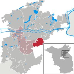
Breydin (German pronunciation: [bʁaɪˈdiːn]) is a municipality in the Barnim district of Brandenburg in Germany.
History
From 1815 to 1947, Breydin was part of the Prussian Province of Brandenburg, from 1947 to 1952 of the State of Brandenburg, from 1952 to 1990 of the East German Bezirk Frankfurt and since 1990 again of Brandenburg.
Demography

Breydin: Population development within the current boundaries (2017)3 | |||||||||||||||||||||||||||||||||||||||||||||||||||||||||||||||||||||||||||||||||||||||||||||||||||||||||||||||||||||||||||||||||||||||||||||||
|
|
| |||||||||||||||||||||||||||||||||||||||||||||||||||||||||||||||||||||||||||||||||||||||||||||||||||||||||||||||||||||||||||||||||||||||||||||
References
References
- Landkreis Barnim Wahl der Bürgermeisterin / des Bürgermeisters. Retrieved 27 June 2024.
- "Bevölkerungsstand im Land Brandenburg Dezember 2024 (Fortgeschriebene amtliche Einwohnerzahlen, basierend auf dem Zensus 2023)" (XLS). Amt für Statistik Berlin-Brandenburg (in German).
- Detailed data sources are to be found in the Wikimedia Commons.Population Projection Brandenburg at Wikimedia Commons