Bohnice | |
|---|---|
Cadastral Area of Prague | |
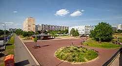 Tenement buildings in Bohnice | |
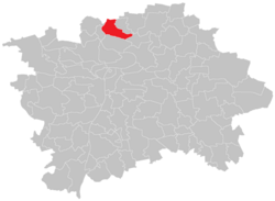 Location of Bohnice in Prague | |
| Coordinates: 50°7′53″N 14°24′39″E / 50.13139°N 14.41083°E / 50.13139; 14.41083 | |
| Country | Czechia |
| Region | Prague |
| District | Prague 8 |
| Area | |
• Total | 4.66 km2 (1.80 sq mi) |
| Population (2021)1 | |
• Total | 16,444 |
| • Density | 3,530/km2 (9,140/sq mi) |
| Time zone | UTC+1 (CET) |
| • Summer (DST) | UTC+2 (CEST) |
| Postal code | 181 00 |
Bohnice (Czech pronunciation: [ˈboɦɲɪtsɛ]) is a cadastral district in Prague 8, Czechia, some 5 km north of the city centre. It is home to a psychiatric hospital and a large tenement housing estate in which all the streets are named after cities or regions of Poland.
-
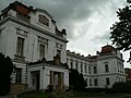 Psychiatric hospital – administrative building with main entrance
 -
 Lodžská (Łódź) Street; names of Polish cities and rivers prevail in the housing estate.
 -
 Krosenská (Krosno) Street
 -
 Saints Peter and Paul Church in the old part of Bohnice, consecrated in 1158.
Demographics
Historical population | ||||||||||||||||||||||||||||||||||||||||||||||||||||||||
|
|
| ||||||||||||||||||||||||||||||||||||||||||||||||||||||
| Source: Censuses21 | ||||||||||||||||||||||||||||||||||||||||||||||||||||||||
References
References
- "Results of the 2021 Census – Open data". Public Database (in Czech). Czech Statistical Office. 27 March 2021.
- "Historický lexikon obcí České republiky 1869–2011 – Praha" (PDF) (in Czech). Czech Statistical Office. 21 December 2015.