Blendecques
Blendeke | |
|---|---|
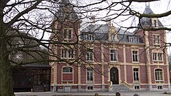 The town hall of Blendecques | |
 Coat of arms | |
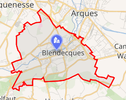 Location of Blendecques | |
Blendecques Blendecques | |
| Coordinates: 50°43′04″N 2°16′38″E / 50.7178°N 2.2772°E / 50.7178; 2.2772 | |
| Country | France |
| Region | Hauts-de-France |
| Department | Pas-de-Calais |
| Arrondissement | Saint-Omer |
| Canton | Longuenesse |
| Intercommunality | Pays de Saint-Omer |
| Government | |
| • Mayor (2020–2026) | Rachid Ben Amor1 |
Area 1 | 9.56 km2 (3.69 sq mi) |
| Population (2023)2 | 4,859 |
| • Density | 508/km2 (1,320/sq mi) |
| Time zone | UTC+01:00 (CET) |
| • Summer (DST) | UTC+02:00 (CEST) |
| INSEE/Postal code | 62139 /62575 |
| Elevation | 7–93 m (23–305 ft) (avg. 25 m or 82 ft) |
| 1 French Land Register data, which excludes lakes, ponds, glaciers > 1 km2 (0.386 sq mi or 247 acres) and river estuaries. | |
Blendecques (French pronunciation: [blɑ̃dɛk]; West Flemish: Blendeke) is a commune in the Pas-de-Calais department in the Hauts-de-France region in northern France.3
Geography
The town is situated 3 miles (5 km) south of Saint-Omer, at the junction of the D77, D210 and D211 roads. The river Aa flows through the commune.4
The town has a football team and a basketball team.
Population
| Year | Pop. | ±% p.a. |
|---|---|---|
| 1968 | 4,431 | — |
| 1975 | 5,014 | +1.78% |
| 1982 | 5,338 | +0.90% |
| 1990 | 5,210 | −0.30% |
| 1999 | 5,186 | −0.05% |
| 2007 | 5,090 | −0.23% |
| 2012 | 5,205 | +0.45% |
| 2017 | 5,002 | −0.79% |
| 2023 | 4,859 | −0.48% |
| Source: INSEE5 | ||
Notable people
- Alfred Machin, filmmaker
- Hugo Vandermersch, footballer
Sights
- The nineteenth-century church of St. Gilles.
- The Chapelle de Soyecques.
- The eighteenth-century Château de La Garenne.
- Another Château of the 19th century.
- The abbey of Sainte-Colombe, dating from the twelfth century.
- The remains of some old watermills and lime-kilns.
References
References
- "Répertoire national des élus: les maires" (in French). data.gouv.fr, Plateforme ouverte des données publiques françaises. 13 September 2022.
- "Populations de référence 2023" (in French). National Institute of Statistics and Economic Studies. 18 December 2025.
- INSEE commune file
- Sandre. "Fiche cours d'eau - Rivière Aa (E4030570)".
- Population municipale entre 1968 et 2023, INSEE
External links
External links
- Football Club Patriote of Blendecques Archived 2009-02-14 at the Wayback Machine (in French)