Bantaeng Regency
Kabupaten Bantaeng | |
|---|---|
| Regional transcription(s) | |
| • Makassar | ᨀᨅᨘᨄᨈᨙ ᨅᨈᨕᨙᨂ |
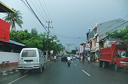 Town of Bantaeng | |
 Seal | |
 Location within South Sulawesi | |
| Country | Indonesia |
| Province | South Sulawesi |
| Capital | Bantaeng |
| Government | |
| • Regent | Fathul Fauzy Nurdin |
| • Vice Regent | Sahabuddin |
| Area | |
• Total | 390.97 km2 (150.95 sq mi) |
| Population (mid 2025 estimate)1 | |
• Total | 221,359 |
| • Density | 566.18/km2 (1,466.4/sq mi) |
| Time zone | UTC+8 (WITA) |
| Website | http://www.bantaeng.go.id |
Bantaeng Regency (Kabupaten Bantaeng; ᨀᨅᨘᨄᨈᨙ ᨅᨈᨕᨙᨂ) is a regency of South Sulawesi Province in Indonesia. It covers an area of 390.97 km2 and had a population of 176,984 at the 2010 Census,2 rising to 196,716 at the 2020 Census.3 The official estimate as at mid 2025 was 221,359 (comprising 109,626 males and 111,723 females).1 The administrative centre is the town of Bantaeng (historically, Bonthain), which lies on the south coast of the southern peninsula of Sulawesi island.
Administration
Bantaeng Regency is divided into eight Districts (Kecamatan), tabulated below with their areas and their populations at the 2010 Census2 and the 2020 Census,3 as well as according to the official estimates for mid 2025.1 The table also includes the locations of the district administrative centres, the numbers of villages in each district (totaling 46 rural desa and 21 urban kelurahan), and its post codes.
| Kode Wilayah |
Name of District (kecamatan) |
Area in km2 |
Pop'n Census 2010 |
Pop'n Census 2020 |
Pop'n Estimate mid 2025 |
Admin centre |
No. of villages |
Post code |
|---|---|---|---|---|---|---|---|---|
| 73.03.01 | Bissappu | 32.84 | 30,931 | 35,356 | 38,935 | Banto Lebang | 11 (a) | 92451 |
| 73.03.06 | Uluere | 63.55 | 10,814 | 11,563 | 13,501 | Banto Marannu | 6 | 92452 |
| 73.03.08 | Sinoa | 43.00 | 11,827 | 13,031 | 14,837 | Banto Maccini | 6 | 92450 |
| 73.03.02 | Bantaeng (town) |
28.87 | 36,718 | 39,597 | 42,479 | Pallantikang | 9 (b) | 92411 -92415 |
| 73.03.03 | Eremerasa | 45.01 | 18,614 | 21,284 | 24,203 | Ulugalung | 9 | 92414 -92415 |
| 73.03.04 | Tompobulu | 75.85 | 22,913 | 24,857 | 27,165 | Banyorang | 10 (c) | 92462 |
| 73.03.05 | Pa'jukukang | 48.90 | 29,017 | 32,331 | 39,367 | Nipa-nipa | 10 | 92460 |
| 73.03.07 | Gantarangkeke | 52.95 | 15,865 | 18,697 | 20,872 | Gantarangteke | 6 (d) | 92461 |
| Totals | 390.97 | 176,699 | 196,716 | 221,359 | Bantaeng | 67 |
Notes: (a) comprises 7 kelurahan (Bonto Atu, Bonto Jaya, Bonto Langkasa, Bonto Lebang, Bonto Manai, Bonto Rita and Bonto Sunggu) and 4 desa.
(b) comprises 8 kelurahan (Karatuang, Lamalaka, Lembang, Letta, Mallilingi, Onto, Pallantikang and Tappanjeng) and 1 desa.
(c) comprises 4 kelurahan (Banyorang, Campaga, Ereng-Ereng and Lembang Gantarangkeke) and 6 desa.
(d) comprises 2 kelurahan (Gantarangkeke and Tanah Loe) and 4 desa.
Climate
Bantaeng has a tropical savanna climate (Aw) with moderate to little rainfall from July to November and heavy rainfall from December to June.
| Climate data for Bantaeng | |||||||||||||
|---|---|---|---|---|---|---|---|---|---|---|---|---|---|
| Month | Jan | Feb | Mar | Apr | May | Jun | Jul | Aug | Sep | Oct | Nov | Dec | Year |
| Mean daily maximum °C (°F) | 29.8 (85.6) |
29.8 (85.6) |
30.3 (86.5) |
31.0 (87.8) |
31.2 (88.2) |
30.9 (87.6) |
31.0 (87.8) |
31.6 (88.9) |
32.0 (89.6) |
32.2 (90.0) |
31.3 (88.3) |
30.1 (86.2) |
30.9 (87.7) |
| Daily mean °C (°F) | 26.3 (79.3) |
26.3 (79.3) |
26.5 (79.7) |
26.8 (80.2) |
26.9 (80.4) |
26.3 (79.3) |
25.8 (78.4) |
26.0 (78.8) |
26.4 (79.5) |
27.0 (80.6) |
27.0 (80.6) |
26.5 (79.7) |
26.5 (79.7) |
| Mean daily minimum °C (°F) | 22.8 (73.0) |
22.9 (73.2) |
22.8 (73.0) |
22.7 (72.9) |
22.6 (72.7) |
21.7 (71.1) |
20.7 (69.3) |
20.4 (68.7) |
20.9 (69.6) |
21.8 (71.2) |
22.8 (73.0) |
22.9 (73.2) |
22.1 (71.7) |
| Average rainfall mm (inches) | 181 (7.1) |
149 (5.9) |
128 (5.0) |
130 (5.1) |
194 (7.6) |
185 (7.3) |
106 (4.2) |
41 (1.6) |
20 (0.8) |
46 (1.8) |
80 (3.1) |
144 (5.7) |
1,404 (55.2) |
| Source: Climate-Data.org4 | |||||||||||||
Tourism

Bantaeng Regency has 3 beaches:5
- Lamalaka Beach
- Seruni Beach
- Marina Beach and Resort
The previous 2 beaches is near the administrative centre, Bantaeng, and the last beach is 18 kilometers southeast of Lamalaka Beach.
References
References
- Badan Pusat Statistik, Jakarta, 27 February 2026, Kabupaten Bantaeng Dalam Angka 2026 (Katalog-BPS 1102001.7303)
- Biro Pusat Statistik, Jakarta, 2011.
- Badan Pusat Statistik, Jakarta, 2021.
- "Climate: Bantaeng". Climate-Data.org. Retrieved 18 November 2020.
- "Bantaeng". July 1, 2012. Archived from the original on 2012-10-05.