| Ball Range | |
|---|---|
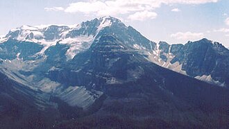 | |
| Highest point | |
| Peak | Mount Ball |
| Elevation | 3,311 m (10,863 ft)12 |
| Listing | |
| Coordinates | 51°09′22″N 116°00′22″W / 51.15611°N 116.00611°W / 51.15611; -116.006113 |
| Dimensions | |
| Length | 26 km (16 mi) W-E4 |
| Width | 35 km (22 mi) N-S4 |
| Geography | |
Ball Range Location in British Columbia Show map of AlbertaBall Range Ball Range (British Columbia) Show map of British Columbia | |
Country | Canada |
Provinces | Alberta and British Columbia |
Range coordinates | 51°09′N 116°01′W / 51.150°N 116.017°W / 51.150; -116.0175 |
| Parent range | Canadian Rockies |
| Topo maps | |
The Ball Range is a mountain range on the Continental Divide between Vermilion Pass and Red Earth Pass in Kootenay National Park, Canada.7 The range is named after John Ball,6 a politician who helped secure funding for the Palliser expedition.
It extends over 465 km2 (180 sq mi), and measures 35 km (22 mi) from North to South and 26 km (16 mi) from East to West.4
Peaks
This range includes the following mountains and peaks:
References
References
- Kane, Alan (1999). "Mount Ball". Scrambles in the Canadian Rockies. Calgary: Rocky Mountain Books. pp. 216–217. ISBN 0-921102-67-4.
- "Mount Ball". cdnrockiesdatabases.ca. Retrieved 2025-03-13.
- "Mount Ball". BC Geographical Names. Government of British Columbia – B.C. Geographical Names Office (BCGNO). Retrieved 2025-03-13.
- "Ball Range". Peakbagger.com. Retrieved 2019-06-11.
- "Ball Range". Geographical Names Data Base. Natural Resources Canada. Retrieved 2019-06-11.
- "Ball Range". BC Geographical Names. Government of British Columbia – B.C. Geographical Names Office (BCGNO). Retrieved 2019-06-11.
- "Ball Range". cdnrockiesdatabases.ca. Retrieved 2019-06-11.