Bajgora
Bajgorë | |
|---|---|
Village | |
 | |
Bajgora Location in Kosovo | |
| Coordinates: 42°57′08″N 21°00′14.4″E / 42.95222°N 21.004000°E / 42.95222; 21.004000 | |
| Location | Kosovo |
| District | Mitrovica |
| Municipality | Mitrovica |
| Population (2024)1 | |
• Total | 327 |
| Time zone | UTC+1 (CET) |
| • Summer (DST) | UTC+2 (CEST) |
Bajgora (Albanian: Bajgorë; Serbian; Бајгора) is a village in the municipality of Mitrovica in Kosovo. It is located in the south of the Kopaonik mountain range. It is just a few kilometers south from the 1,789 m (5,869 ft) high Bajraku peak. According to the 2011 census, it had 1,098 inhabitants, all ethnic Albanians.2 It is part of the region known as Shala e Bajgorës.
Bajgora was the scene of Kosovo Liberation Army activity during the Kosovo War of 1999.34
Notable people
- Bislim Bajgora, Adjutant for the Balli Kombetar forces of Kosovo
- Mehë Uka, educator and polticial prisoner honoured with the Hero of Kosovo Order5
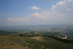
Gallery
-
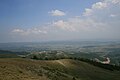 Overview
 -
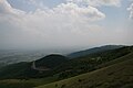 Another Overview
References
References
- "Popullsia sipas gjinisë, etnicitetit dhe vendbanimit" [Population by gender, ethnicity, and place of residence] (PDF) (in Albanian). Prishtinë: Kosovo Agency of Statistics. July 2025.
{{cite web}}: CS1 maint: url-status (link) - 2011 Kosovo Census results
- Chris Bird (January 12, 1999). "Shooting of aide puts Kosovo on brink of war". The Guardian.
- Steven Erlanger (May 11, 1999). "Crisis in the Balkans: The Serbs; Belgrade Says Pullout In Kosovo Has Begun". The New York Times.
- "Mehë Ramë Uka". Radio Kosova e Lirë (in Albanian). 29 December 2023. Retrieved 21 January 2024.