Bagaces | |
|---|---|
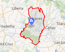 Interactive map of Bagaces | |
Bagaces Bagaces district location in Costa Rica | |
| Coordinates: 10°26′53″N 85°17′35″W / 10.4481144°N 85.2931365°W / 10.4481144; -85.2931365 | |
| Country | |
| Province | Guanacaste |
| Canton | Bagaces |
| Area | |
• Total | 883.98 km2 (341.31 sq mi) |
| Elevation | 80 m (260 ft) |
| Population (2011) | |
• Total | 12,367 |
| • Density | 13.990/km2 (36.234/sq mi) |
| Time zone | UTC−06:00 |
| Postal code | 50401 |
Bagaces is a district of the Bagaces canton, in the Guanacaste province of Costa Rica.12
Geography
Bagaces has an area of 883.98 km2 (341.31 sq mi)3 and an elevation of 80 metres.1
Communities
The district includes the towns of Bagaces, Pijije, Montenegro, Montano, and Salitral.
Demographics
| Census | Pop. | ±% p.a. |
|---|---|---|
| 1883 | 517 | — |
| 1892 | 419 | −2.31% |
| 1927 | 1,890 | +4.40% |
| 1950 | 4,079 | +3.40% |
| 1963 | 9,836 | +7.01% |
| 1973 | 4,867 | −6.79% |
| 1984 | 5,909 | +1.78% |
| 2000 | 9,261 | +2.85% |
| 2011 | 12,367 | +2.66% |
| 2022 | 15,858 | +2.29% |
| Source: Instituto Nacional de Estadística y Censos4 Centro Centroamericano de Población5 | ||
For the 2011 census, Bagaces had a population of 12,367 inhabitants.6
Transportation
Road transportation
The Inter-American Highway runs east–west through the middle of the district.
The district is covered by the following road routes:
References
References
- "Declara oficial para efectos administrativos, la aprobación de la División Territorial Administrativa de la República N°41548-MGP". Sistema Costarricense de Información Jurídica (in Spanish). 19 March 2019. Retrieved 26 September 2020.
- División Territorial Administrativa de la República de Costa Rica (PDF) (in Spanish). Editorial Digital de la Imprenta Nacional. 8 March 2017. ISBN 978-9977-58-477-5.
- "Área en kilómetros cuadrados, según provincia, cantón y distrito administrativo". Instituto Nacional de Estadística y Censos (in Spanish). Archived from the original on 24 October 2020. Retrieved 26 September 2020.
- "Instituto Nacional de Estadística y Censos" (in Spanish).
- Centro Centroamericano de Población de la Universidad de Costa Rica. "Sistema de Consulta a Bases de Datos Estadísticas" (in Spanish).
- "Censo. 2011. Población total por zona y sexo, según provincia, cantón y distrito". Instituto Nacional de Estadística y Censos (in Spanish). Retrieved 26 September 2020.