| Authion | |
|---|---|
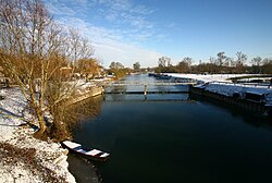 The Authion in Brain-sur-l'Authion | |
| Location | |
| Country | France |
| Physical characteristics | |
| Mouth | Loire |
• coordinates | 47°25′17″N 0°33′09″W / 47.4213°N 0.5525°W / 47.4213; -0.5525 |
| Length | 99.8 km (62.0 mi) |
Basin size | 1,497 km2 (578 sq mi) |
| Basin features | |
| Progression | Loire→ Atlantic Ocean |
The Authion (French pronunciation: [otjɔ̃]) is a 99.8 km (62.0 mi) long river in western France located in the departments of Indre-et-Loire (Centre-Val de Loire) and Maine-et-Loire (Pays de la Loire). It is a tributary of the river Loire on the right side.1 It flows into the Loire in Sainte-Gemmes-sur-Loire, near Angers. Its longest tributaries are the Lathan and the Couasnon.1 The largest towns on the Authion are Bourgueil, Mazé-Milon, Brain-sur-l'Authion, Trélazé and Les Ponts-de-Cé. Its basin area is 1,497 km2 (578 sq mi).2