| Augstenberg | |
|---|---|
| Piz Blaisch Lunga | |
 Augstenberg on the right. | |
| Highest point | |
| Elevation | 3,230 m (10,600 ft) |
| Prominence | 432 m (1,417 ft)1 |
| Parent peak | Piz Buin |
| Listing | Alpine mountains above 3000 m |
| Coordinates | 46°51′52″N 10°12′13″E / 46.864444°N 10.203611°E / 46.864444; 10.203611 |
| Geography | |
Augstenberg Location in the Alps | |
| Location | Graubünden, Switzerland/Tyrol, Austria |
| Parent range | Silvretta Alps |
| Climbing | |
| First ascent | 23 August 1881 by C. Blezinger and E. Renner, guided by Peter Reinstadler and the brothers Lorenz. |
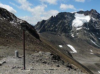
The Augstenberg (also known as Piz Blaisch Lunga) is a mountain in the Silvretta Alps, located on the border between Austria and Switzerland. It has an elevation of 3,230 metres (10,597 ft) above sea level. A secondary summit on the south has an elevation of 3,225 metres. On its eastern side, the Augstenberg overlooks the Pass Futschöl (2,768 m).