Amdal | |
|---|---|
Village | |
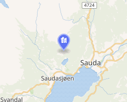 Interactive map of Amdal | |
| Coordinates: 59°39′30″N 6°19′03″E / 59.6584°N 6.31743°E / 59.6584; 6.31743 | |
| Country | Norway |
| Region | Western Norway |
| County | Rogaland |
| District | Ryfylke |
| Municipality | Sauda Municipality |
| Elevation | 204 m (669 ft) |
| Time zone | UTC+01:00 (CET) |
| • Summer (DST) | UTC+02:00 (CEST) |
| Post Code | 4208 Saudasjøen |
Amdal2 is a small farming village in Sauda Municipality in Rogaland county, Norway. The village is located just a short distance inland from the Saudafjorden, about 1.5 kilometres (0.93 mi) north of the village of Saudasjøen and about 2.5 kilometres (1.6 mi) west of the town of Sauda.
References
References
- "Amdal, Sauda". yr.no. Retrieved 2026-02-04.
- "Informasjon om stadnamn". Norgeskart (in Norwegian). Kartverket. Retrieved 2026-02-04.