Zijdewind | |
|---|---|
Village | |
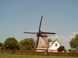 | |
Zijdewind Location in the Netherlands Show map of NetherlandsZijdewind Location in the province of North Holland in the Netherlands Show map of North Holland | |
| Coordinates: 52°44′38″N 4°50′20″E / 52.74389°N 4.83889°E / 52.74389; 4.83889 | |
| Country | Netherlands |
| Province | North Holland |
| Municipality | Hollands Kroon |
| Area | |
• Village | 2.24 km2 (0.86 sq mi) |
| Elevation | −0.8 m (−2.6 ft) |
| Population (2025)1 | |
• Village | 405 |
| • Density | 181/km2 (468/sq mi) |
| • Urban | 290 |
| • Rural | 110 |
| Time zone | UTC+1 (CET) |
| • Summer (DST) | UTC+2 (CEST) |
| Postal code | 17361 |
| Dialing code | 0226 |
Zijdewind (West Frisian: Sidewind) is a village in the Dutch province of North Holland. It is a part of the municipality of Hollands Kroon, and lies about 8 km north of Heerhugowaard.
The village was first mentioned in 1421 as Nuwe Nyedorper Zydwijnde, and means "sidewards located dike".3 Zijdewind started as a peat excavation village. In 1652, a church was built, but was decommissioned. It was used as a farm and often mockingly called the cow church. In 1970, it was demolished to make way for a roundabout.4
The statistical area "Zijdewind", which also can include the surrounding countryside, has a population of around 310.5
References
References
- "Kerncijfers wijken en buurten 2025" [Key figures districts and neighborhoods 2025]. Central Bureau of Statistics. Retrieved 6 November 2025.
- "Postcodetool for 1736AA". Actueel Hoogtebestand Nederland (in Dutch). Het Waterschapshuis. Archived from the original on 21 September 2013. Retrieved 30 April 2022.
- "Zijdewind - (geografische naam)". Etymologiebank (in Dutch). Retrieved 30 April 2022.
- "Zijdewind". Plaatsengids (in Dutch). Retrieved 30 April 2022.
- Statistics Netherlands (CBS), Statline: Kerncijfers wijken en buurten 2003-2005. As of 1 January 2005.