Xonobod | |
|---|---|
 | |
Xonobod Location in Uzbekistan | |
| Coordinates: 40°48′N 73°0′E / 40.800°N 73.000°E / 40.800; 73.000 | |
| Country |  Uzbekistan Uzbekistan |
| Region | Andijan Region |
| Tuman/City | Xonobod |
| Area | |
• Total | 20 km2 (7.7 sq mi) |
| Population (2022)1 | |
• Total | 44,000 |
| • Density | 2,200/km2 (5,700/sq mi) |
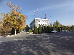
Xonobod (in 1972—91 Sovetabad, Uzbek: Xonobod, Хонобод Russian: Ханабад, romanized: Khanabad) is a district-level city in Andijan Region, Uzbekistan.2 It has an area of 20 km2 (7.7 sq mi)3 and 44,000 inhabitants (2020).1 It lies to the east of Andijan in the Ferghana Valley, on the right bank of the Kara Darya.
References
References
- "Hududlar bo'yicha shahar va qishloq aholisi soni" [Urban and rural population by district] (PDF) (in Uzbek). Andijan regional department of statistics.
- "Classification system of territorial units of the Republic of Uzbekistan" (in Uzbek and Russian). The State Committee of the Republic of Uzbekistan on statistics. July 2020.
- Xonobod city Archived 2024-05-18 at the Wayback Machine, Andijan region