| Wiveliscombe | |
|---|---|
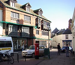 Court House, Wiveliscombe, built by the Hancock family (a local brewing family) in 18811 | |
Wiveliscombe Location within Somerset | |
| Population | 3,064 (Parish, 2021)2 |
| OS grid reference | ST080279 |
| Civil parish |
|
| Unitary authority | |
| Ceremonial county | |
| Region | |
| Country | England |
| Sovereign state | United Kingdom |
| Post town | TAUNTON |
| Postcode district | TA4 |
| Dialling code | 01984 |
| Police | Avon and Somerset |
| Fire | Devon and Somerset |
| Ambulance | South Western |
| UK Parliament | |
Wiveliscombe (/ˈwɪvəlɪskəm, ˌwɪvəˈlɪskəm/, locally /ˈwɪlskəm/)4 is a town and civil parish in Somerset, England. It lies 9 miles (14 km) west of Taunton, its post town. The town is centred on The Square, which held the former market and is fronted by several listed buildings. As well as the town itself, the parish covers surroundings rural areas, including the hamlets of Croford, Langley, Maundown, and Whitefield. At the 2021 census, the parish had a population of 3,064.
History
Settlement in the neighbourhood is of long standing. The Neolithic hillfort at King's Castle is 1 kilometre (0.6 mi) east of the town. North west of the town is Clatworthy Camp, an Iron Age hillfort. Nearby is Elworthy Barrows, an unfinished Iron Age hillfort, rather than Bronze Age barrows.5 A rectangular enclosure south of Manor Farm is the remains of a Roman fort;6 in the 18th century, vestiges of its fortifications and foundations were identified as being of Roman origin, and it was locally called "the Castle".7 In the 18th century a hoard of about 1600 Roman coins of third and fourth century dates was uncovered.8
The Anglo-Saxon settlement, the combe or valley of a certain Wifele,9 was mentioned in the Domesday Book of 1086, when it was quite large, consisting of twenty-seven households, with an annual value to the lord, the Bishop of Wells St Andrew, of £25.10 During the Middle Ages the bishops maintained a residence here, the foundations of which were found in 2021.11
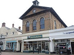
Wiveliscombe Town Hall was built in 1840 by Somerset surveyor Richard Carver for Lord Ashburton. It housed a fish market, a butchers' market and a pig market, with an assembly room above them. It is a Grade II listed building.12 By 2010, plans were drawn up for the creation there of an arts, media, cultural and heritage venue.13 The Abbotsfield cottages were built by businessman Lukey Collard in the 1870s;14 they became a Grade II listed building in 1975.
In 2010 a new 10 Parishes Centre was announced to provide a new community facility alongside the Children's Centre being built at Croft Way.15
Governance
There are two tiers of local government covering Wiveliscombe, at parish (town) and unitary authority level: Wiveliscombe Town Council and Somerset Council. The town council meets at the Wiveliscombe Community Centre on West Street.16
For national elections, Wiveliscombe forms part of the Tiverton and Minehead constituency.17
Administrative history
Wiveliscombe was an ancient parish in the Kingsbury hundred of Somerset. The parish historically included the chapelry of Fitzhead, which became a separate parish for civil purposes at an early date and became a separate ecclesiastical parish in 1737.1819
In 1859, a local government district was established covering the town, administered by an elected local board. Such districts were reconstituted as urban districts under the Local Government Act 1894, which also directed that civil parishes could no longer straddle district boundaries. The civil parish of Wiveliscombe was therefore reduced to match the urban district, and the surrounding rural parts of the parish became a separate civil parish called Wiveliscombe Without.2021
Wiveliscombe Urban District was abolished in 1933. The civil parish was then reclassified as a rural parish, given a parish council instead of an urban district council, and included in the Wellington Rural District.19 The two parishes of Wiveliscombe and Wiveliscombe Without were not reunited at the time of the 1933 reforms, but were eventually reunited as one civil parish of Wiveliscombe in 1986.22
Wellington Rural District was abolished in 1974 under the Local Government Act 1972, with its area becoming part of the new Taunton Deane district.2324 As part of the 1974 reforms, parish councils were given the right to declare their parishes to be a town and take the title of town council,25 which Wiveliscombe Parish Council has taken, becoming Wiveliscombe Town Council.16
Taunton Deane was abolished in 2019, becoming part of the short-lived district of Somerset West and Taunton, which was in turn abolished four years later in 2023. Somerset County Council then took over district-level functions across its area, making it a unitary authority, and was renamed Somerset Council.26
Geography
Wiveliscombe is a former borough, market and cloth making town,27 5 miles (8 km) from the border between Devon and Somerset. It is situated at the foot of the Brendon Hills and acts as a gateway to Exmoor. At an altitude of 126 m (413 ft) Wiveliscombe is the highest town in Somerset after Dulverton.
The town used to have a station on the Devon and Somerset Railway which closed in 1966. Clatworthy Reservoir is nearby.
Demography
The town's population in 1777 was 1,533.28 While the modern population is small for a town, its shops and services meet the needs of a much larger population, spread through the western fifth of Taunton Deane, in scattered farms and villages. A survey in 1997 revealed that there were at least 300 businesses within a 5-mile (8 km) radius of the town; 14 of these were trading internationally and a further 20 nationally. Wiveliscombe is also home to three breweries, Cotleigh Brewery (but closed in 2021), Exmoor Ales and Black Bear Brewery . It is also one of the first towns in the UK to set up a completely free goods and services exchange forum for the local ten parishes area.29
The community radio station 10Radio30 is based in the town, serving the community of the ten parishes from which its name is derived. 105.3FM in the local area and via the internet.
Churches

The previous parish church was valued in 1292 at 12 marks.31 The present church, dedicated to St Andrew, is a grade II* listed building.32 It was built in 1827-9; the architect was Richard Carver who had it built from red sandstone with Hamstone dressings. Its octagonal font originated in the 14th century, and in the churchyard is a 14th-century sandstone cross.33
The oldest place of worship in Wiveliscombe is the Congregational Chapel in Silver Street, built in 1708 as the Independent Chapel. It joined the Congregational Union of England and Wales in 1838, and is now used by the Wiveliscombe Evangelical Congregational Church. This chapel was built because the Independent Meeting House (built in 1689 after the Act of Toleration) had become too small. This earlier Meeting House was demolished sometime after the First World War, when North Street Motors was built on the site. This has now closed, and the premises are currently being used as a garden shop.
Media
Television signals are received from either the Stockland Hill or Mendip TV transmitters. Local radio stations are BBC Radio Somerset on 95.5 FM, Heart West on 96.5 FM, Greatest Hits Radio South West (formerly The Breeze (Bridgwater & West Somerset) on 107.4 FM, and 10Radio, a community based station which broadcast on 105.3 FM and also online.34 Local newspapers are Somerset County Gazette and West Somerset Free Press.35
Education
Wiveliscombe Primary School serves most of the surrounding villages from ages 4 to 11. Kingsmead School, for pupils aged 11 to 16, houses a Theatre and Sports Hall and a youth club complementing the town's Recreation Ground where the Tennis, Rugby, Cricket and Football Clubs have their bases.
Notable people
- Frederick William Collard (1772-1860), a British piano manufacturer.36
- William Brown (1861–1931), veterinary surgeon, social reformer, Quaker minister and JP.37
- William Hancock (1873–1910), an ophthalmologist and assistant surgeon at the Royal London Ophthalmic Hospital. He also played a first-class cricket match for Somerset in 1892.38
- Ann Way (1915–1993), a film and television character and actress.39
References
References
- Historic England. "Nos 5 & 7 The Square (1307465)". National Heritage List for England. Retrieved 16 February 2008.
- "2021 Census Parish Profiles". NOMIS. Office for National Statistics. Retrieved 20 April 2026. (To get individual parish data, use the query function on table PP002.)
- "Wiveliscombe Town Council Website". Wiveliscombe Town Council. Retrieved 23 August 2023.
- Jones, Daniel (2011). Roach, Peter; Setter, Jane; Esling, John (eds.). Cambridge English Pronouncing Dictionary (18th ed.). Cambridge University Press. ISBN 978-0-521-15255-6.
- Barrow, "Hllforts and hilltops 1000BC - 1000AD" in Aston and Burrow, The Archaeology of Somerset (1982)
- "Roman fort, SE of Wiveliscombe". Somerset Historic Environment Record. Somerset County Council. Retrieved 17 August 2014.
- John Collinson, The History and Antiquities of Somerset 1791 vol II, p. 488; Collinson notes that several Roman coins were discovered within the site in 1711.
- Collinson 1791, p. 488.
- BBC: Domesday Reloaded: Wiveliscombe.
- Open Domesday: Wiveliscombe.
- "Remains of bishop's palace found in Palace Gardens, Wiveliscombe | Somerset County Gazette". 11 March 2021.
- Historic England. "Town Hall (1307454)". National Heritage List for England. Retrieved 14 May 2010.
- "Wiveliscombe town hall". Somerset Rural Renaissance. Retrieved 14 May 2010.
- Tim, Welch (8 July 2014). Joseph Smale: God's 'Moses' for Pentecostalism. Authentic Publishers. p. 42. ISBN 978-1-78078-320-8.
- "Building links at Wiveliscombe". Somerset Rural Renaissance. Retrieved 14 May 2010.
- "Wiveliscombe Town Council". Retrieved 4 May 2026.
- "Election Maps". Ordnance Survey. Retrieved 4 May 2026.
- "Somerset Hundreds". GENUKI. Retrieved 16 October 2011.
- Youngs, Frederic (1979). Guide to the Local Administrative Units of England: Volume I, Southern England. London: Royal Historical Society. p. 443. ISBN 0901050679.
- Kelly's Directory of Somerset. 1914. p. 539. Retrieved 4 May 2026.
- "Somerset: Diagram showing administrative boundaries". National Library of Scotland. Ordnance Survey. 1972. Retrieved 4 May 2026.
- Langston, Brett. "Taunton Deane Registration District". UK BMD. Retrieved 4 May 2026.
- "The English Non-metropolitan Districts (Definition) Order 1972", legislation.gov.uk, The National Archives, SI 1972/2039, retrieved 21 April 2026
- "The English Non-metropolitan Districts (Names) Order 1973", legislation.gov.uk, The National Archives, SI 1973/551, retrieved 3 March 2023
- "Local Government Act 1972: Section 245", legislation.gov.uk, The National Archives, 1972 c. 70 (s. 245), retrieved 13 April 2024
- "The Somerset (Structural Changes) Order 2022: Article 3", legislation.gov.uk, The National Archives, SI 2022/329 (art. 3), retrieved 20 July 2024
- The woollen industry at Wivelscombe specialized in rough kerseys and baize, which were traded to Bristol and London and exported to Guernsey and Spain (Collinson, p. ).
- Collinson, p. 188.
- "Wiveliscombe". Somerset Market Towns. Retrieved 9 July 2008.
- http://www.10radio.org/ Community Radio for the 10 Parishes
- Collinson, pp 486ff.
- Historic England. "Church of St Andrew (1177072)". National Heritage List for England. Retrieved 15 February 2008.
- Historic England. "Churchyard cross, Church of St Andrew (1177103)". National Heritage List for England. Retrieved 16 February 2008.
- "10Radio". Retrieved 21 December 2023.
- "West Somerset Free Press". British Papers. 26 November 2013. Retrieved 21 December 2023.
- Boase, George Clement (1887). . Dictionary of National Biography. Vol. 11. pp. 330–331.
- "Death of Mr. William Brown". Western Gazette. 2 October 1931. p. 14. Retrieved 13 January 2025 – via Newspapers.com.
- "Obituary: William Ilbert Hancock, F.R.C.S." British Medical Journal. 1 (2562): 357. 1910. doi:10.1136/bmj.1.2562.357. PMC 2330421.
- "BFI biodata". Archived from the original on 14 January 2009. Retrieved 29 April 2010.
External links
External links
- Wiveliscombe at The Somerset Urban Archaeological Survey, by Clare Gathercole