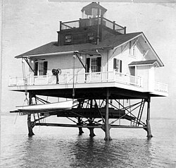
 Wade Point Light (USCG) | |
 | |
| Location | Entrance to Pasquotank River, North Carolina |
|---|---|
| Coordinates | 36°09′22″N 75°58′40″W / 36.1561°N 75.9778°W / 36.1561; -75.9778 |
| Tower | |
| Foundation | screw-pile |
| Construction | cast-iron/wood |
| Height | 39 feet (12 m) |
| Shape | square house |
| Light | |
| First lit | 1855 |
| Lens | fourth-order Fresnel lens |
| Characteristic | fixed white |

The Wade Point Light was a screw-pile lighthouse in North Carolina.
History
Lightship "M" was stationed at the mouth of the Pasquotank River off Albemarle Sound beginning in 1826. In 1855 it was replaced by a square screw-pile structure . This structure was eventually removed and replaced with the Pasquotank River Entrance Light, an automated tower about two miles NNE of the previous light.
References
References
- "Historic Light Station Information and Photography: North Carolina". United States Coast Guard Historian's Office. Archived from the original on 2017-09-23. Retrieved 2008-10-07.
- Light List, Volume II, Atlantic Coast, Shrewsbury River, New Jersey to Little River, South Carolina (PDF). Light List. United States Coast Guard. 2007. p. 297.
- "U.S. Lightship Station Assignments". United States Coast Guard. Retrieved 2008-10-07.