Val d'Arry | |
|---|---|
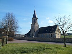 The church in Missy | |
Location of Val d'Arry | |
Val d'Arry Location within France Show map of FranceVal d'Arry Location within Normandy Show map of Normandy | |
| Coordinates: 49°07′19″N 0°34′01″W / 49.122°N 0.567°W / 49.122; -0.567 | |
| Country | France |
| Region | Normandy |
| Department | Calvados |
| Arrondissement | Vire |
| Canton | Les Monts d'Aunay |
| Intercommunality | Pré-Bocage Intercom |
| Government | |
| • Mayor (2020–2026) | Christian Vengeons1 |
Area 1 | 24.54 km2 (9.47 sq mi) |
| Population (2023)2 | 2,496 |
| • Density | 101.7/km2 (263.4/sq mi) |
| Time zone | UTC+01:00 (CET) |
| • Summer (DST) | UTC+02:00 (CEST) |
| INSEE/Postal code | 14475 /14210, 14310 |
| 1 French Land Register data, which excludes lakes, ponds, glaciers > 1 km2 (0.386 sq mi or 247 acres) and river estuaries. | |
Val d'Arry (French pronunciation: [val daʁi]) is a commune in the department of Calvados, northwestern France. The municipality was established on 1 January 2017 by merger of the former communes of Noyers-Missy (the seat), Le Locheur and Tournay-sur-Odon.3
Geography
The commune is made up of the following collection of villages and hamlets, Brettevillette, Missy, Noyers-Bocage, La Flaguais, La Félière, Val d'Arry, Ragny, Villodon and La Bruyère.4
Two rivers flow through the commune, The Odon and the Ajon.56 In addition five streams the Ruisseau de la Pigaciere, Ruisseau de la Picardiere, Ruisseau d'O, Ruisseau du Val Chesnel and the Ruisseau du Douet Banneville traverse the commune.7891011
Population
Population data refer to the commune in its geography as of January 2025.
| Year | Pop. | ±% p.a. |
|---|---|---|
| 1968 | 1,256 | — |
| 1975 | 1,293 | +0.42% |
| 1982 | 1,394 | +1.08% |
| 1990 | 1,741 | +2.82% |
| 1999 | 1,911 | +1.04% |
| 2007 | 2,330 | +2.51% |
| 2012 | 2,276 | −0.47% |
| 2017 | 2,256 | −0.18% |
| 2023 | 2,496 | +1.70% |
| Source: INSEE12 | ||
Points of Interest
National Heritage sites
The Commune has two buildings and areas listed as a Monument historique13
- Église Saint-Jacques du Locheur a church listed as a monument in 1928.14
- Eglise Saint-Jean-Baptiste a thirteenth century church, listed as a monument in 1927.15
Architecture contemporaine remarquable
- Église de l'Assomption Notre-Dame - a church built between 1954 and 1960 and designed by the architect Charles Musetti, in 2002 it was awarded the Architecture contemporaine remarquable label.16
References
References
- "Répertoire national des élus: les maires" (in French). data.gouv.fr, Plateforme ouverte des données publiques françaises. 13 September 2022.
- "Populations de référence 2023" (in French). National Institute of Statistics and Economic Studies. 18 December 2025.
- Arrêté préfectoral 8 September 2016 (in French)
- "Val d'Arry · France". Val d'Arry · France.
- Sandre. "Fiche cours d'eau - L'Odon (I26-0400)".
- Sandre. "Fiche cours d'eau - Ajon (I2630600)".
- Sandre. "Fiche cours d'eau - Ruisseau de la Pigaciere (I2642000)".
- Sandre. "Fiche cours d'eau - Ruisseau de la Picardiere (I2643500)".
- Sandre. "Fiche cours d'eau - Ruisseau d'O (I2643000)".
- Sandre. "Fiche cours d'eau - Ruisseau du Val Chesnel (I2641000)".
- Sandre. "Fiche cours d'eau - Ruisseau du Douet Banneville (I2628000)".
- Population municipale entre 1968 et 2023, INSEE
- "Les Monuments Historiques en Calvados - 14". monumentum.fr.
- "Eglise à Val d'Arry - PA00111501 - Monumentum". monumentum.fr.
- "Eglise Saint-Jean-Baptiste à Val d'Arry - PA00111552 - Monumentum". monumentum.fr.
- "Église de l'Assomption Notre-Dame à Val d'Arry". Monumentum (in French). Retrieved 10 January 2026.