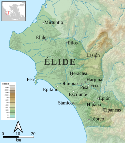
37°30′32″N 21°48′22″E / 37.5088°N 21.8062°E / 37.5088; 21.8062 Typaneae or Typaniai (Ancient Greek: Τυπανέαι,12 Τυμπανέαι,3 or Τυμπάνεια4), also Latinized as Tympaneae, was a town of Triphylia in ancient Elis, a possible successor settlement to Homeric Aepy.56 It is mentioned by Strabo along with Hypana near the rivers Dalion and Acheron, tributaries of Alpheus.3 It was taken by Philip V of Macedon in the Social War.1 It was situated in the mountains in the interior of the country.
Its site has been located near modern Vresto,78 though other writers disagree and propose other locations.9
References
References
- Polybius. The Histories. Vol. 4.77-79.
- Stephanus of Byzantium. Ethnica. Vol. s.v.
- Strabo. Geographica. Vol. 8.3.15. Page numbers refer to those of Isaac Casaubon's edition.
- Ptolemy. The Geography. Vol. 3.16.18.
- Smith, William, ed. (1854–1857). "Typanaea". Dictionary of Greek and Roman Geography. London: John Murray.
- Platiana
- Lund University. Digital Atlas of the Roman Empire.
- Talbert, Richard, ed. (2000). Barrington Atlas of the Greek and Roman World. Princeton University Press. p. 58. ISBN 978-0-691-03169-9, with accompanying Map-by-Map Directory.
- It has been suggested by Juan José Torres Esbarranch that it can be identified with remains, among which there is a theatre, located on a hill 5 km (3 mi) from the modern town of Platiana (Juan José Torres Esbarranch (2001). Estrabón, Geografía libros VIII-X (in Spanish). Madrid: Gredos. p. 59, n. 160. ISBN 84-249-2298-0.), but the Greek Ministry of Culture proposes that these remains could have belonged to the ancient Hypana. (Page of the Ministry of Culture of Greece: the acropolis of Platiana (in Greek))
This article incorporates text from a publication now in the public domain: Smith, William, ed. (1854–1857). "Typaneae". Dictionary of Greek and Roman Geography. London: John Murray.