Tortisambert | |
|---|---|
Part of Livarot-Pays-d'Auge | |
 | |
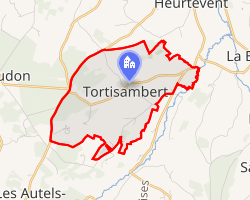 Location of Tortisambert | |
Tortisambert Tortisambert | |
| Coordinates: 48°58′01″N 0°07′06″E / 48.9669°N 0.1183°E / 48.9669; 0.1183 | |
| Country | France |
| Region | Normandy |
| Department | Calvados |
| Arrondissement | Lisieux |
| Canton | Livarot-Pays-d'Auge |
| Commune | Livarot-Pays-d'Auge |
Area 1 | 6.07 km2 (2.34 sq mi) |
| Population (2023)1 | 126 |
| • Density | 20.8/km2 (53.8/sq mi) |
| Time zone | UTC+01:00 (CET) |
| • Summer (DST) | UTC+02:00 (CEST) |
| Postal code | 14140 |
| Elevation | 77–213 m (253–699 ft) (avg. 159 m or 522 ft) |
| 1 French Land Register data, which excludes lakes, ponds, glaciers > 1 km2 (0.386 sq mi or 247 acres) and river estuaries. | |
Tortisambert (French pronunciation: [tɔʁtizɑ̃bɛʁ]) is a former commune in the Calvados department in the Normandy region of northwestern France. On 1 January 2016, it was merged into the new commune of Livarot-Pays-d'Auge and became a delegated commune.2
Geography
The commune of Tortisambert covered an area of 6.07 km², with elevations ranging from 77 m to 213 m above sea level.3
Heritage and notable sites
- A 16th-century manor, known as the Manoir de la Varinière, is a listed monument4
References
References
- "Populations de référence 2023" [Reference populations 2023] (PDF) (in French). INSEE. December 2025.
- Arrêté préfectoral 24 December 2015 (in French)
- Des villages de Cassini aux communes d'aujourd'hui: Commune data sheet Tortisambert, EHESS (in French).
- Base Mérimée: Manoir de la Varinière, Ministère français de la Culture. (in French)