| Tolisa | |
|---|---|
Location within Bosnia and Herzegovina | |
 | |
| Location | |
| Country | Bosnia and Herzegovina |
| Physical characteristics | |
| Source | |
| • location | on the slopes of Trebava |
| Mouth | |
• location | Sava, between Tolisa, Orašje and Domaljevac |
• coordinates | 45°03′25″N 18°38′43″E / 45.05694°N 18.64528°E / 45.05694; 18.64528 1 |
| Length | 56.2 km (34.9 mi) 2 |
| Basin features | |
| Progression |
Sava→ Danube→ Black Sea |
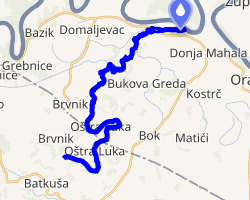
Tolisa is a river in Bosnia and Herzegovina, a right tributary Sava. It is 56.2 kilometers long.3 It springs on the slopes of Trebava at an altitude of 440 meters, and flows into the Sava between Tolisa, Orašje and Domaljevac. The altitude of the estuary is 81 meters.4
The other village in Bosnia called Tolisa, Modriča is located to the southwest where the upstream part of this river is in the Bosna watershed. A lateral canal was built in 1973 that routed mountain streams near Modriča into the Bosna in order to prevent flooding.5
References
References
- Tolisa, Federation of Bosnia and Herzegovina, Bosnia and Herzegovinaa Mindat.org
- "Sava River Basin Analysis Report" (PDF). International Sava River Basin Commission. September 2009. p. 14. Archived from the original (PDF, 9.98 MB) on 2010-07-17.
- "Rijeke i jezera" [Rivers and lakes]. fzs.ba. Archived from the original on 28 August 2011. Retrieved 3 May 2011.
- Rijeka Tolisa
- "Vodoprivreda" (in Serbo-Croatian). Municipality of Modriča.