Timia | |
|---|---|
Commune and town | |
 | |
Timia Location in Niger | |
| Coordinates: 18°6′52″N 8°46′45″E / 18.11444°N 8.77917°E / 18.11444; 8.77917 | |
| Country |  Niger Niger |
| Region | Agadez Region |
| Department | Ifferoune Department |
| Area | |
• Total | 7,452 sq mi (19,301 km2) |
| Population (2020) | |
• Total | 25,005 |
| • Density | 3.3554/sq mi (1.2955/km2) |
| Time zone | UTC+1 (WAT) |
Timia is a small town and commune in northern Niger, situated at an oasis in the Aïr Mountains, Agadez Region, Arlit Department. Visitors come to the Tuareg town to see a seasonal waterfall, a former French fort and the nearby ruined town of Assodé.1 As of 2020, the commune had a total population of 25,005 people.23
Timia lies south of Iferouane and north of Agadez. The main town lies around 3 km from a stone guelta oasis, which holds water year round. It is also known for its fruit trees, an unusual sight in the Saharan regions of northern Niger.4
Gallery
-
 The valleys of Timia
 -
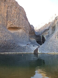 The Oasis of Timia
 -
 In the valley
 -
 Well in Timia
References
References
- Decalo, Samuel (1997). Historical Dictionary of the Niger (3rd ed.). Boston & Folkestone: Scarecrow Press. ISBN 0-8108-3136-8.
- "Niger: Municipal Division (Departments and Communes) - Population Statistics, Charts and Map". www.citypopulation.de. Retrieved 2024-02-21.
- "Annuaires_Statistiques" (PDF). Institut National de la Statistique. Retrieved 2 May 2013.
- Geels, Jolijn (2006). Niger. Chalfont St Peter, Bucks / Guilford, Connecticut: Bradt UK / Globe Pequot Press. ISBN 978-1-84162-152-4.