 State Highway Loop 7 | ||||
|---|---|---|---|---|
| Jed Robinson Loop Dewitt C. Greer Loop | ||||
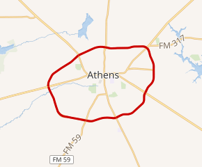 SH Loop 7; highlighted in red | ||||
| Route information | ||||
| Maintained by TxDOT | ||||
| Length | 16.6 mi1 (26.7 km) | |||
| Existed | 20051–present | |||
| Major junctions | ||||
| Beltway around Athens | ||||
| Major intersections |
| |||
| Location | ||||
| Country | United States | |||
| State | Texas | |||
| Highway system | ||||
| ||||


Loop 7 is a beltway in the U.S. state of Texas around the town of Athens. The highway additionally serves as a bypass for U.S. Highway 175 (US 175), State Highway 19 (SH 19), and SH 31 around the town.
Route description
Loop 7 officially begins at an interchange with SH 31 (West Corsicana Street) west of downtown Athens. SH 31 overlaps with Loop 7 and the two highways turn northeast before having an interchange with US 175; that highway then joins the overlap as well. The beltway turns towards the east and has an interchange with SH 19; SH 19 joins the beltway. Loop 7 continues to run east with SH 31 leaving at an interchange with Business SH 31 (Bus. SH 31, East Tyler Street). Loop 7 turns south at the interchange and has an interchange with Farm to Market Road 2495 (FM 2495). Loop 7 starts turning southeast with US 175 leaving at an interchange with Bus. US 175 (E. Corsicana Street). After US 175 leaves the beltway, Loop 7 turns west with SH 19 leaving at an interchange with Bus. SH 19 (South Palestine Street). After SH 19 leaves the beltway, Loop 7 travels without any concurrences and has an interchange with FM 59 and FM 2494. After the FM 2494 interchange, Loop 7 turns north before arriving back at its start point with SH 31 (West Corsicana Street).
History
Previous route
Loop 7 (1939)
 State Highway Loop 7 | |
|---|---|
| Location | Jasper County |
| Existed | September 26, 1939–January 26, 1965 |
A previous route numbered Loop 7 was designated on September 26, 1939, as a loop off US 59 (now US 96) through Jasper as a renumbering of SH 8 Spur. On June 12, 1945, the road was reassigned to old US 96 while the former route of Loop 7 became a portion of US 96.2 This Loop 7 was cancelled on January 26, 1965.3
Current route
The section of Loop 7 from SH 31 (West Corsicana Street) to FM 317 was originally the westernmost section of FM 317. This portion of FM 317 was redesignated as Loop 7 on January 28, 2005.4 On May 30, 2013, SH 31 was rerouted around Athens, bypassing the town and overlapping with Loop 7.5
Junction list
The entire route is in Henderson County. All exits are unnumbered.
| Location | mi | km | Destinations | Notes | |
|---|---|---|---|---|---|
| Athens | 0.0 | 0.0 |     SH 31 west / Bus. SH 31 east – Corsicana, Athens SH 31 west / Bus. SH 31 east – Corsicana, Athens | Interchange; counter-clockwise end of SH 31 concurrency | |
 US 175 west / Bus. US 175 east – Mabank, Athens US 175 west / Bus. US 175 east – Mabank, Athens | Interchange; counter-clockwise end of US 175 concurrency | ||||
   SH 19 north / Bus. SH 19 south – Canton, Athens SH 19 north / Bus. SH 19 south – Canton, Athens | Interchange; counter-clockwise end of SH 19 concurrency | ||||
 FM 1616 north – Murchison FM 1616 north – Murchison | |||||
| SH 31 east / Bus. SH 31 west – Tyler, Athens | Interchange; clockwise end of SH 31 concurrency | ||||
 FM 2495 – Texas Freshwater Fisheries Center FM 2495 – Texas Freshwater Fisheries Center | Interchange | ||||
| US 175 west / Bus. US 175 east – Jacksonville, Athens | Interchange; clockwise end of US 175 concurrency | ||||
| SH 19 south / Bus. SH 19 north – Palestine, Athens | Interchange; clockwise end of SH 19 concurrency | ||||
| |  FM 59 – Cayuga, Athens FM 59 – Cayuga, Athens | Interchange | |||
| | 16.6 | 26.7 |  FM 2494 FM 2494 | Interchange | |
1.000 mi = 1.609 km; 1.000 km = 0.621 mi
| |||||
References
References
- Transportation Planning and Programming Division (n.d.). "State Highway Loop No. 7". Highway Designation Files. Texas Department of Transportation. Retrieved October 12, 2016.
- "Minutes" (PDF). publicdocs.txdot.gov. Texas Department of Transportation. June 12, 1945. Archived (PDF) from the original on February 23, 2018. Retrieved April 28, 2023.
- "Minutes" (PDF). publicdocs.txdot.gov. Texas Department of Transportation. January 25, 1965. Archived (PDF) from the original on October 7, 2017. Retrieved April 28, 2023.
- Transportation Planning and Programming Division (n.d.). "Farm to Market Road No. 317". Highway Designation Files. Texas Department of Transportation. Retrieved October 12, 2016.
- Transportation Planning and Programming Division (n.d.). "State Highway No. 31". Highway Designation Files. Texas Department of Transportation. Retrieved October 12, 2016.