Taybad
Persian: تايباد | |
|---|---|
City | |
Taybad | |
| Coordinates: 34°44′27″N 60°46′45″E / 34.74083°N 60.77917°E / 34.74083; 60.7791712 | |
| Country | Iran |
| Province | Razavi Khorasan |
| County | Taybad |
| District | Central |
| Population (2016)3 | |
• Total | 56,562 |
| Time zone | UTC+3:30 (IRST) |
| Website | www |
| Taybad at GEOnet Names Server | |
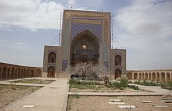
Taybad (Persian: تايباد)a is a city in northeastern of Iran. The city is the Central District of Taybad County, Razavi Khorasan province, serving as capital of both the county and the district.5 Taybad is near the border with Afghanistan.
Demographics
Religion
While most Iranians, and especially most Iranian Persians, are predominantly Shia, a majority of the population of Taybad are Persian Sunnis.67
Population
At the time of the 2006 National Census, the city's population was 46,228 in 10,230 households.8 The 2011 census counted 52,280 people in 12,954 households.9 At the 2016 census, the population of the city was 56,562 people in 14,996 households.3
References
References
- OpenStreetMap contributors (4 November 2024). "چهارراه پست [Post Crossroads], Taybad, دهستان پائین ولایت, بخش مرکزی شهرستان تایباد [Pain Velayat Rural District, Central District of Taybad County], Taybad County, Razavi Khorasan, Iran" (Map). OpenStreetMap (in Persian). Retrieved 4 November 2024.
- "PQRH+8MM Taybad, Razavi Khorasan Province, Iran" (Map). Google Maps. Retrieved 28 March 2026.
- سرشماري عمومي نفوس و مسكن 1395 : استان خراسان رضوی [General Population and Housing Census 2016: Razavi Khorasan Province]. مرکز آمار ایران [Statistical Centre of Iran] (in Persian). Archived from the original (Excel) on 2 April 2022. Retrieved 19 December 2022.
- Taybad at GEOnet Names Server
- Habibi, Hassan (12 September 1990) [تاریخ تصویب (Approval date) 1369.6.21 (Iranian Jalali calendar)]. تصویب سازمان و سلسله تابعیت عناصر و واحدهای تقسیمات کشوی استان خراسان به مرکزیت شهر مشهد [Approval of the organization and chain of citizenship of the elements and units of the divisions of Khorasan province, centered in Mashhad]. مرکز پژوهشهای مجلس شورای اسلامی ایران [Research Center of the Islamic Consultative Assembly of Iran] (in Persian). وزارت کشور [Ministry of the Interior]. کمیسیون سیاسی دفاعی هیأت دولت [Political Defense Commission of the Government Board]. 84902ت125ک [84902T125K]. Archived from the original on 17 November 2015. Retrieved 31 January 2026.
- Vatanka, Alex (12 April 2011). "The Islamic Republic's Cross-Sectarian Outreach". Hudson Institute. Retrieved 1 April 2021.
- "The Persian Sunnis of Iranian Khorasan". Sons of Sunnah. 4 August 2018. Retrieved 1 April 2021.
- سرشماري عمومي نفوس و مسكن 1385 : استان خراسان رضوی [General Population and Housing Census 2006: Razavi Khorasan Province]. مرکز آمار ایران [Statistical Centre of Iran] (in Persian). Archived from the original (Excel) on 20 September 2011. Retrieved 25 September 2022.
- سرشماري عمومي نفوس و مسكن 1390 : استان خراسان رضوی [General Population and Housing Census 2011: Razavi Khorasan Province]. Iran Data Portal—Syracuse University (in Persian). مرکز آمار ایران [Statistical Centre of Iran]. Archived from the original (Excel) on 20 January 2023. Retrieved 19 December 2022.