Tanques | |
|---|---|
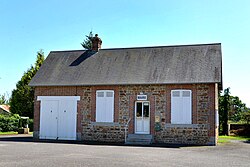 The town hall in Tanques | |
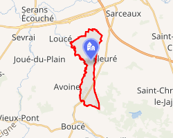 Location of Tanques | |
Tanques Tanques | |
| Coordinates: 48°41′17″N 0°04′19″W / 48.6881°N 0.0719°W / 48.6881; -0.0719 | |
| Country | France |
| Region | Normandy |
| Department | Orne |
| Arrondissement | Argentan |
| Canton | Magny-le-Désert |
| Intercommunality | Terres d'Argentan Interco |
| Government | |
| • Mayor (2020–2026) | Lucienne Morin1 |
Area 1 | 6.22 km2 (2.40 sq mi) |
| Population (2023)2 | 157 |
| • Density | 25.2/km2 (65.4/sq mi) |
| Time zone | UTC+01:00 (CET) |
| • Summer (DST) | UTC+02:00 (CEST) |
| INSEE/Postal code | 61479 /61150 |
| Elevation | 153–234 m (502–768 ft) (avg. 163 m or 535 ft) |
| 1 French Land Register data, which excludes lakes, ponds, glaciers > 1 km2 (0.386 sq mi or 247 acres) and river estuaries. | |
Tanques (French pronunciation: [tɑ̃k] ⓘ) is a commune in the Orne department in north-western France.
Geography
The commune is made up of the following collection of villages and hamlets, Mengné, Les Coudraies and Tanques.3
The commune is within the area known as the Plaine d'Argentan, which is known for its cereal growing fields and horse stud farms.4
The commune is within the Normandie-Maine Regional Natural Park and Forêt d'Écouves.56
Tanques along with another 65 communes is part of a 20,593 hectare, Natura 2000 conservation area, called the Haute vallée de l'Orne et affluents.7
It is 620 hectares (2.4 sq mi) in size. The highest point in the commune is 166 metres (545 ft). The River Cance, Marais de Fleuriel stream and the Bel Usse stream flow through the commune.8
References
References
- "Répertoire national des élus: les maires" (in French). data.gouv.fr, Plateforme ouverte des données publiques françaises. 13 September 2022.
- "Populations de référence 2023" (in French). National Institute of Statistics and Economic Studies. 18 December 2025.
- "Tanques · France". Tanques · France.
- "Normandie Développement Durable" (PDF).
- "rapport de charte" (PDF), parc-naturel-normandie-maine.fr/
- "MASSIF FORESTIER D'ECOUVES ET SES MARGES" (PDF). ZNIEFF.
- "INPN - FSD Natura 2000 - FR2500099 - Haute vallée de l'Orne et affluents - Description".
- Sandre. "Fiche cours d'eau - Cance (I21-0420)".