Tabalong Regency
Kabupaten Tabalong | |
|---|---|
| Other transcription(s) | |
| • Jawi | تابلوڠ |
 Coat of arms | |
| Motto: Saraba Kawa (Banjarese) (Versatile) | |
 | |
| Country | Indonesia |
| Province | South Kalimantan |
| Capital | Tanjung |
| Government | |
| • Regent | Muhammad Noor Rifani |
| • Vice Regent | Habib Muhammad Taufani Alkaf |
| Area | |
• Total | 3,553.36 km2 (1,371.96 sq mi) |
| Population (mid 2025 estimate) | |
• Total | 271,216 |
| • Density | 76.3266/km2 (197.685/sq mi) |
| 1 | |
| Time zone | UTC+8 (WITA) |
| Area code | +62 526 |
| HDI (2019) | |
| Website | tabalongkab.go.id |
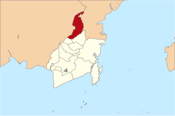
Tabalong Regency is the northernmost regency in the Indonesian province of South Kalimantan, on Borneo Island. It was created on 14 July 1965 by splitting off the former northern districts of North Hulu Sungai Regency. It has a land area of 3,553.36 km2, and had a population at the 2010 Census of 218,6203 and 253,305 at the 2020 Census;4 the official estimate as of mid 2025 was 271,216 (comprising 137,096 males and 134,120 females).1 The administrative capital is the town of Tanjung. The Regency's motto is "Saraba Kawa" (versatile in Banjarese).
Administrative divisions
The Regency is divided into twelve districts (Indonesian: kecamatan), tabulated below with their areas and population totals from the 2010 Census,3 and the 2020 Census,4 together with the official estimates for mid 2025.1 The table also includes the locations of the district administrative centres, the number of administrative villages in each district (a total of 121 rural desa and 10 urban kelurahan), and its postal codes.
| Kode Wilayah |
Name of District (kecamatan) |
Area in km2 |
Pop'n Census 2010 |
Pop'n Census 2020 |
Pop'n Estimate mid 2025 |
Admin centre |
No. of villages |
Post codes |
|---|---|---|---|---|---|---|---|---|
| 63.09.01 | Banua Lawas | 150.86 | 17,997 | 20,201 | 21,667 | Banua Lawas | 15 | 71553 (a) |
| 63.09.09 | Pugaan | 31.87 | 6,479 | 7,443 | 7,980 | Halangan | 7 | 71554 |
| 63.09.02 | Kelua | 53.39 | 22,628 | 24,911 | 26,182 | Pulau | 12 (b) | 71552 |
| 63.09.08 | Muara Harus | 26.78 | 5,901 | 6,795 | 7,343 | Tantaringin | 7 | 71555 |
| 63.09.03 | Tanta | 149.73 | 17,204 | 22,168 | 25,119 | Tanta | 14 | 71561 |
| 63.09.04 | Tanjung | 191.69 | 32,440 | 35,899 | 38,146 | Jangkung | 15 (c) | 71515 (d) |
| 63.09.06 | Murung Pudak | 172.48 | 44,688 | 56,790 | 60,824 | Belimbing Raya | 10 (e) | 71571 |
| 63.09.05 | Haruai | 271.97 | 20,416 | 23,688 | 24,889 | Halong | 13 | 71570 |
| 63.09.12 | Bintang Ara | 1,170.19 | 7,935 | 9,146 | 9,759 | Uish | 9 | 71572 |
| 63.09.10 | Upau | 183.01 | 7,046 | 7,366 | 7,960 | Pangelak | 6 | 71575 |
| 63.09.07 | Muara Uya | 877.13 | 21,689 | 23,839 | 25,276 | Muara Uya | 14 | 71573 |
| 63.09.11 | Jaro | 274.26 | 14,197 | 15,059 | 16,071 | Jaro | 9 | 71574 |
| Totals | 3,553.36 | 218,620 | 253,903 | 271,216 | Tanjung | 131 |
Notes: (a) except the village of Sungai Durian (postcode of 72167). (b) including one kelurahan - the town of Pulau. (c) including 4 kelurahan - Agung, Hikun, Jangkung and Tanjung. (d) except the town of Tanjung (postcode of 71513) and the towns of Jangkung (postcode of 71512) and Agung (postcode of 71514). (e) including 5 kelurahan - Belimbing, Belimbing Raya, Mabu'un, Pembataan and Sulingan.
References
References
- Badan Pusat Statistik, Jakarta, 27 February 2026, Kabupaten Tabalong Dalam Angka 2026 (Katalog-BPS 1102001.6309)
- Indeks Pembangunan Manusia Kabupaten Tabalong, Badan Pusat Statistik, 2018
- Biro Pusat Statistik, Jakarta, 2011.
- Badan Pusat Statistik, Jakarta, 2021.